Project Summary
The excavations at the Byzantine rural settlement of Kilise Tepe are providing new primary data for the changing nature of rural settlement and economy in lsauria between the 4th and 13th centuries AD. This preliminary report provides a summary of the Byzantine work which took place during our final excavation season in July and August 2011.
Introduction
")
The investigation of the Byzantine levels at Kilise Tepe represents one of the first significant excavations of a Byzantine rural settlement in south-central Anatolia. The Byzantine levels represent approximately 1m of archaeological deposits lying on top of a 13m-high mound dating to the Early Bronze Age. The location of the mound at Kilise Tepe provides an ideal case study both for rural settlement and for settlement history in Isauria since it lies in an agricultural basin of the strategic Göksu valley that links the Mediterranean to central Anatolia. The archaeological preservation of the Byzantine buildings, although buried close to the surface of the mound, is remarkably good. We are therefore able to investigate the dynamics of this rural settlement by contextualizing relationships at different scales: between the artifacts and features within a room, and between structures within the site. At the same time we are able to consider Kilise Tepe as a case study for the region which, from the mid-7th century, found itself close to the frontier zone with the new Islamic empire.
Mounds such as Kilise Tepe have often been ignored by Byzantinists, and yet such rural settlements represent a very important dataset for understanding the lives of a significant proportion of the Byzantine population. Kilise Tepe therefore provides an interesting and important contrast to the contemporary monumental ecclesiastical site at Alahan, excavated by Michael Gough, lying further north in the Göksu valley, and the coastal towns and cities, such as Anemurium, excavated by James Russell, Elaiussa Sebaste, currently under excavation by Professor E. Equini Schneider (La Sapienza, Rome), and Aydincık, directed by Professor L. Zoroğlu (Selçuk University, Konya). The work at Kilise Tepe also complements surveys carried out further north in the valley by the Göksu Archaeological Project, directed recently by Prof. H. Elton (Trent), and at the limestone settlements close to Silifke, directed by Dr. G. Varinlioğlu (Dumbarton Oaks). Kilise Tepe also provides primary evidence for an agricultural community whose inhabitants were involved both in local and wider economic and social networks, participation that we can see, for example, in the exchange of ceramics and the contents of ceramic vessels, marble, glass, ground stone, as well as the storage and processing of crops and animal bones.
We are therefore interested in levels of subsistence, exchange, and production at Kilise Tepe both at particular periods and through time. One of the benefits of contextualizing the Byzantine phases within the wider (multi-period) Kilise Tepe Archaeological Project, and specifically the excavation of environmental evidence from earlier periods, is the opportunity for us to consider the Byzantine activities against a long-term sequence of change. We can ask, for example, to what extent patterns of production and subsistence in the Byzantine period are different from or typical of this site in other periods.
The analysis of individual buildings and their position within the wider settlement allows us to consider the activities that were taking place in the social spaces inside and outside the houses and in the settlement as a whole. By contextualizing the evidence from artifacts, and by using environmental sampling, we will be able to consider the dynamics of everyday rural life in Byzantine Anatolia in ways rarely attempted before.
The position of Kilise Tepe on a terrace above the River Göksu makes it an ideal calibrator for settlement dynamics in the region, in particular because of the perceived growth in settlement density across the eastern provinces in the early Byzantine period, followed in the frontier zone by a period about which we know relatively little. The impact of Persian and Arab invasions on areas inland is especially unknown. (Varinlioğlu 2007, 312). The location of Kilise Tepe inside Byzantine territory, in a pass protected by the castle at Seleuceia (Silifke), close to the broad frontier zone with the Islamic empire, makes Kilise Tepe an important case study for the period. The implications of the chronology of Kilise Tepe have been recognized but further work has been needed to clarify the date of the final early Byzantine phase (Brubaker and Haldon 2011, 503).
Previous Work
In 2007 the excavations from 1994–98 at Kilise Tepe were published (Postgate and Thomas 2007). The focus of the Byzantine work in the 1990s was on the church and revealed that an early Byzantine basilica was destroyed and subsequently replaced by a medieval church and cemetery dating to the 12th century (Jackson 2007). The current program of excavations 2007–11 has concentrated on the features of the rural settlement around these monumental structures (Jackson and Postgate 2008; Jackson 2009a; Collon, Jackson, and Postgate 2009; Jackson and Postgate 2010; Jackson forthcoming). Results of these seasons have been integrated into a GIS in order to facilitate their storage, analysis and interpretation.
The buildings comprising the settlement around the church are made of undressed and unmortared fieldstones and mostly have plastered or occasionally flagged stone floors. There are two main phases of early Byzantine buildings, the walls of which are preserved to a height of between one and five courses above the floors. The artifacts lying on the floors in the final phase have been largely protected from damage by more recent activity on the mound, including ploughing and stone robbing. The similarity of ceramic types between the rooms in different areas of the site where excavations have taken place and the nature of the preservation of artifacts in these spaces strongly suggests that the buildings were abandoned in a hurry. Thus the evidence from abandoned rooms at three different parts of the site has enabled us to argue for a sudden end to the occupation sequence connected to the final early Byzantine phase (Collon, Jackson and Postgate 2009).
The discovery of the artifacts lying in situ on the floors from this phase of activity appears to reflect their abandonment at a particular moment in time. This relatively unusual archaeological preservation enabled us to record the location of artifacts from a small number of rooms so that meaningful interpretations can be suggested for the kinds of activities that took place within these spaces.
Byzantine Work at Kilise Tepe in 2011
In 2011 we sought to continue to throw more light on the layout and chronology of the Byzantine domestic architecture at Kilise Tepe. Our main aim was to identify contexts that belonged to the abandonment of the early Byzantine phase at Kilise Tepe and to confirm their date.
A resistivity survey was conducted successfully in March 2011 when we sought to clarify as far as possible the layout and plan of the Byzantine settlement using RM15 Geoscan survey equipment. This took place in the spring while the ground was still moist enough for the technology to work and in time for us to use the results to plan our program of excavations in the summer. This resistivity survey complemented other remote sensing, including magnetometry and aerial photography, carried out in earlier seasons. The results of the resistivity survey were imported into our Geographical Information System (GIS) so that the new data could be explored in the light of our previous results and in order to inform our preparations for the summer.
The GIS enabled us to combine layered datasets so that we could see the excavated walls and other features running into the unexcavated areas; this in effect enabled us to link the plans of buildings in many of the excavated trenches. We can explore these data further by including other information collected as part of previous seasons’ work, such as the artifact scatters and the magnetometer survey carried out in 2007.
Of note we can highlight:
- The similar alignment of the Byzantine buildings across much of the southern half of the site. To the southeast of the church. The presence of these structures is particularly clear and complements well previous work in area Nl2a, as well as Nl4-15 and 014-15.
- The linear features running along the east side of the mound, which appear perhaps to represent the perimeter wall excavated partly in the early 1990s
- The area along the northern edge of the mound where the walls partially exposed and planned in 1994 clearly continue to the north
- The presence of structures east of the church whose plan is less easily discernible. The resistivity survey completed in March-April 2011 showed a complex of ten rooms in squares between N12 and PI2.
The successful results of the resistivity survey added considerably to our understanding of the mound and helped to inform our decision making for the final phase of excavation at the site.
Objectives for Summer 2011
Our objectives for the summer season in July and August 2011 were:
- to locate potential Byzantine domestic architecture for excavation in the hope of recovering well-stratified Byzantine domestic material.
- to identify contexts that belonged to the abandonment of the Early Byzantine phase at Kilise Tepe and to confirm their date, as well as to consider further the nature of early Byzantine domestic occupation at the end of this sequence.
- to investigate the commencement of the Byzantine phase and to consider the relationship of Byzantine features with the Hellenistic levels sealed beneath.
- to process finds and write up field reports from the 2011 season in the field.
In order to achieve these objectives, excavations took place in three areas: (a) a large area consisting of two trenches located southeast of the church in squares N13–N14, and N11–N12, O11–O12; (b) sampling of areas east of the church in L17–M17; and (c) a long narrow trench northwest of the church on the edge of the mound in I17–18. We are pleased to report that all these objectives were met successfully.
A. Southeast of the Church
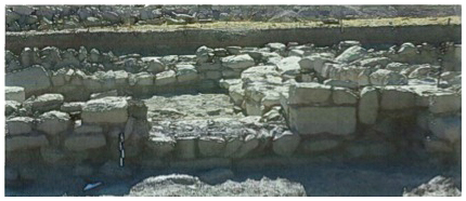
Our main focus was the building complex located between N12 and P12 to the southeast of the church. In squares N12, O12, N11 and O11, we excavated six rooms from the west end of this complex. Four rooms in N11 and N12c and d, arranged in a square, represented the focus of an early Byzantine domestic complex. This pan of the building measured c. 10m (east-west) x 12.6m (north-south) and had two additional structures constructed on the east side in O11a and O12c.
The foundation courses of walls, floors, and the internal features within these early Byzantine dwellings were well preserved and will facilitate detailed understanding of the activities which took place within them.
The thresholds between rooms will enable reconstruction of movement between these spaces. In addition, the phasing of the walls allows us to build up a picture of how the complex developed through time.
")
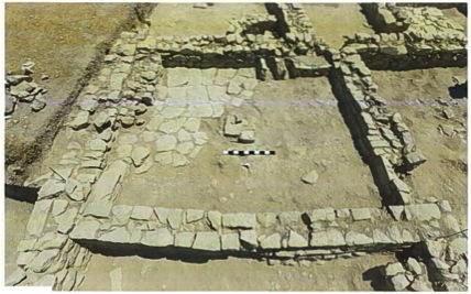
Floors were usually made from hardened earth or were sometimes plastered, but occasionally they were paved or partially paved, as in the room in N12d. Each room had a central stone feature, presumably for supporting a vertical wooden post (visible in N12d, partially preserved in the center of the room). Notice also the bench along the North Wall and the steps down into the room (at the west end of the north wall, associated with the threshold in the wall immediately east of the iron peg). Several of the rooms also had fire installations set into benches made of stone and mud-brick (as in N12d at the south end of the east wall).
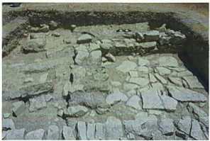
The early stages of excavation revealed beneath the topsoil a mixture of collapsed mud brick and stones. This represented the remains of the collapsed buildings and gives us a good indication of the construction materials of the upper courses of the buildings that previously existed above the surviving stone foundations.
Underneath this destruction debris in O11a there was an external area with a plastered floor. The features and artifacts contextualized within these early Byzantine living spaces will enable detailed understanding of the activities that took place within and around these dwellings. On the east side of this space, for example, built up against the west side of wall W5602, there was a fire installation FI11/7. This fire installation was surrounded by several objects which lay in situ on the floor including: two stone mortars (O12/57 and O12/58), a copper chain, presumably from a glass lamp (O11/064), several ceramic vessels, and a clay lamp (O11/071).
The ceramics and other finds from the rooms in the structure have been quantified and recorded and will be integrated into the GIS as part of the post-excavation process. Of note from the southwest room of the building in N11 was an early Byzantine jar painted on the shoulder with fish and other motifs, including foliage. This represents a new example of the painted repertoire which is typical of the early Byzantine vessels from this site and nearby Alahan. These local wares typically have red painted decoration on their shoulders (Jackson 2008; Jackson 2009b). The cooking wares and amphorae from this structure allow us to build up a picture of the local ceramic assemblage, in particular at the end of the sequence.
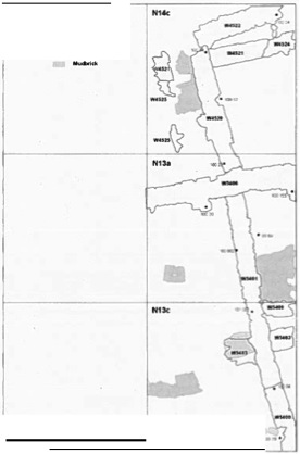
In order to link this complex to the area excavated in previous seasons we extended a trench from N12a (excavated in 1994) north into N13 and N14, where we were able to clarify the relative relationships of the architectural phases in this area. In N14c, the Byzantine walls were resting on an earlier Hellenistic fill, represented by a burnt destruction deposit, which yielded a number of Hellenistic-period ceramic vessels lying on a floor. These closed forms have been reconstructed and add considerably to our understanding of the Hellenistic ceramic assemblage at Kilise Tepe, and help to clarify the commencement of the early Byzantine phase, which here, as elsewhere on the mound, appears to have begun without an earlier Roman phase.
B. East of the Church
We performed some minor soundings directly east of the church, in squares L17 and M17, recording the line of robber trenches and room fills in order to clarify further the plan of the buildings there. The remainder of the central paved area in L17 excavated in 2009 was exposed for planning.
C. Northwest of the Church
North of the church, we completed the excavation of a long sondage in I17a and H18c, where it was demonstrated that a short exposed stretch of a large mortared wall, 1.30m wide and running east-west, had formerly returned north. A robber trench marked its former position. This robbed wall appears to have returned east into the east section. A series of ash and plaster layers, most likely representing the continuation of those excavated in the area to the north during the 1990s (Jackson 2007: 208), were shown to have respected the easterly return of this now robbed wall.
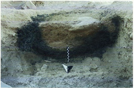
The remains of a plaster floor at the base of the robber trench preserved the impressions of the stones from this robbed wall. Apparently up against the east side of the former N-3 wall and cutting the floor surface which was beneath the wall, a pit (P11/045) was found filled with a large quantity of carbonized wheat (Triticum). This was sampled (I17/036) for C14 dating. Botanical analysis of such deposits will complement the work by D. Heslop on the ground stone to further our understanding of the Byzantine rural economy. A radiocarbon date has been received for this deposit of wheat (dated by the Oxford Radiocarbon Accelerator Unit OxA-26218 66: I17/036 charred seeds [Triticum sp.] -22.71 909 ± 26) to 1036–1207 2σ Cal AD (Sula pers. Comm. 12/06/2012). This date range shows that the storage of wheat in this pit took place when the cemetery around the later church was in use. In addition to clarifying the dating of the stratigraphy in this part of the mound, this pit represents important evidence for crop processing and storage close to the smaller secondary church in the late period when it was the focus for a cemetery.
Post-Excavation Work
All trench reports were completed by the team in the field after the excavation finished. All architectural drawings were scanned and georeferenced in GIS during the season and the architectural plans digitized. Post-excavation analysis has continued in Newcastle with the digitizing of individual archaeological contexts from the field drawings by T. Sutcliffe. Artifact drawings have also been prepared for publication and specialists have been working on their final reports. A further study season will take place in Turkey during 2012 involving principally our conservator, photographer, and finds specialists. We are preparing the digital archive for the Byzantine levels to be made available together with the archive for the rest of the Kilise Tepe Archaeological Project online via the Archaeological Data Service, York.
Acknowledgments
On the tepe the hard work of digging and removing soil was done for us by workmen from Kışla village. Trench supervisors for the Byzantine work were S. Moore, with J. Dunn, F. Lalor, J. M. Levell, L. Proctor, A. Sangsterm and T. Sutcliffe from Newcastle.
Bob Miller again took charge of the photography of both site and artifacts, and T. Sutcliffe generated the digital architectural plans. The finds database was maintained by Frances Mcintosh, with assistance from Dr. D. Collon, and S. Poll assisted with the documentation. The flotation of soil samples was carried out by Melissa Sharp. Dr. Jackson directed the recording of the Byzantine material, and David Heslop (County Archaeologist, Tyne and Wear) examined all our ground stone, both from the 1990s in the Museum at Silifke and the material excavated in 2007-11. Dr. M. O’Hea (Adelaide) came to continue her work on the Byzantine glass; glass samples have been exported and will be examined by Dr. Nadine Schibille (Oxford). The metal artifacts were studied by F. McIntosh (Newcastle University). Unfortunately our conservator Fran Cole took ill in 2011, and therefore the coins excavated in 2011 will be conserved and photographed in the 2012 season and subsequently analyzed, as in previous years, by Sam Moorhead (British Museum).
The Representative of the Ministry of Culture and Tourism was Sn Kürşat Kaynat, to whom we are most grateful, not least for his prompt arrival at very short notice. As always we are deeply grateful to Ilhame Oztiirk, Director of the Silifke Museum, for her support and advice. We would also like to express our gratitude to the British Institute at Ankara for their ongoing support, and especially to Gülgün Girdivan for her readiness to address all our problems and her ability to solve them. The work in 2011 was principally funded by a generous grant from the Arts and Humanities Research Council for research on the Bronze and Iron Age levels, while the Byzantine work would not have been possible without generous grants from Dumbarton Oaks, Washington, DC, and Newcastle University; to all donors we are very grateful.
Bibliography
Brubaker, L. and J. Haldon. 2011. Byzantium in the Iconoclast Era (ca 680-850). Cambridge: Cambridge University Press.
Collon, D., M. Jackson, and N. Postgate. 2009. “Excavations at Kilise Tepe 2008.” Kazı Sonuçları Toplantısı 31:159–84.
Jackson, M. 2012. “A Byzantine Settlement at Kilise Tepe in the Goksu Valley.” In Rough Cilicia: New Archaeological and Historical Approaches, edited by M. Hoff. Oxford and Oakville, CT: Oxbow Books.
———. 2009a. “Medieval Rural Settlement at Kilise Tepe in the Goksu Valley.” In Archaeology of the Countryside in Medieval Anatolia, edited by J. J. Roodenberg, 71–83. Leiden: Nederlands Instituut voor het Nabije Oosten.
———. 2009b. “Byzantine Ceramics from the Excavations at Kilise Tepe 2007 and Recent Research On Pottery From Alahan.” Araştırma Sonuçları Toplantısı 26.2:159–74.
———. 2008. “Local Painted Pottery Trade in Early Byzantine Isauria.”' In Byzantine Trade, 4th–12th Centuries: The Archaeology of Local, Regional and International Exchange, edited by M. M. Mango, 137–44. Farnham and Burlington, VT: Ashgate.
———. 2007. “The Byzantine Stratigraphy: The Church, Level I: I-M14”; “Level I: North West Corner”; “Level I: NE Corner Sub Surface.” In Excavations at Kilise Tepe, 1994–98: From Bronze Age to Byzantine in Western Cilicia, ed. J. N. Postgate and D. C. Thomas, 185–211.
Jackson, M. and N. Postgate. 2010. “Kilise Tepe 2009 Yılı Kazıları.” Kazı Sonuçarı Toplantısı 32.3:424–46.
———. 2008. “Excavations at Kilise Tepe 2007.” Kazı Sonuçarı Toplantısı 30:207–32.
Postgate, J. N. and D. C. Thomas, eds. 2007. Excavations at Kilise Tepe, 1994–98: From Bronze Age to Byzantine in Western Cilicia. London and Ankara: McDonald Institute for Archaeological Research I British Institute of Archaeology at Ankara.
Varinlioğlu, G. 2007. “Living in a Marginal Environment: Rural Habitat and Landscape in Southeastern Isauria.” DOP 61:287–317.
-
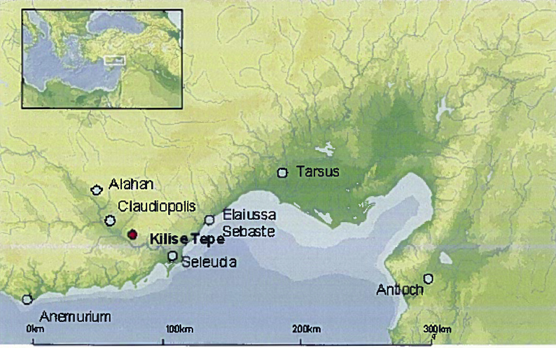
 Fig. 1: Map of Cilician region showing Kilise Tepe and other sites in the Goksu Valley (Jackson 2011–2012)
Fig. 1: Map of Cilician region showing Kilise Tepe and other sites in the Goksu Valley (M. Jackson).
Fig. 1: Map of Cilician region showing Kilise Tepe and other sites in the Goksu Valley (Jackson 2011–2012)
Fig. 1: Map of Cilician region showing Kilise Tepe and other sites in the Goksu Valley (M. Jackson).
-
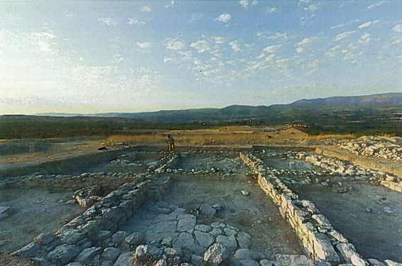
 Fig. 2: Mound at Kilise Tepe from the east (Jackson 2011–2012)
Fig. 2: Mound at Kilise Tepe from the east (Bob Miller).
Fig. 2: Mound at Kilise Tepe from the east (Jackson 2011–2012)
Fig. 2: Mound at Kilise Tepe from the east (Bob Miller).
-
 Fig. 3: Low-resolution screenshot from the ArcGIS database for the Byzantine phases of Kilise Tepe (Jackson 2011–2012)
Fig. 3: Low-resolution screenshot from the ArcGIS database for the Byzantine phases of Kilise Tepe showing the central part of the mound with the main Byzantine buildings excavated up until end of 2009 (grid 10m x 10m) (M. Jackson).
Fig. 3: Low-resolution screenshot from the ArcGIS database for the Byzantine phases of Kilise Tepe (Jackson 2011–2012)
Fig. 3: Low-resolution screenshot from the ArcGIS database for the Byzantine phases of Kilise Tepe showing the central part of the mound with the main Byzantine buildings excavated up until end of 2009 (grid 10m x 10m) (M. Jackson).
-
 Fig. 4: Alexander Turner and Tuncay Korkmaz conducting Resistivity Survey in March 2011 prior to the summer excavation season (Jackson 2011–2012)
Fig. 4: Alexander Turner and Tuncay Korkmaz conducting Resistivity Survey in March 2011 prior to the summer excavation season (M. Jackson).
Fig. 4: Alexander Turner and Tuncay Korkmaz conducting Resistivity Survey in March 2011 prior to the summer excavation season (Jackson 2011–2012)
Fig. 4: Alexander Turner and Tuncay Korkmaz conducting Resistivity Survey in March 2011 prior to the summer excavation season (M. Jackson).
-
 Fig. 5: Low-resolution screenshot from the ArcGIS database for the Byzantine phases of Kilise Tepe (Jackson 2011–2012)
Fig. 5: Low-resolution screenshot from the ArcGIS database for the Byzantine phases of Kilise Tepe showing the central part of the mound with the main Byzantine buildings excavated before 2011 together with the 2011 resistivity survey results (each grid square 10m x 10m) (M. Jackson and A. Turner).
Fig. 5: Low-resolution screenshot from the ArcGIS database for the Byzantine phases of Kilise Tepe (Jackson 2011–2012)
Fig. 5: Low-resolution screenshot from the ArcGIS database for the Byzantine phases of Kilise Tepe showing the central part of the mound with the main Byzantine buildings excavated before 2011 together with the 2011 resistivity survey results (each grid square 10m x 10m) (M. Jackson and A. Turner).
-
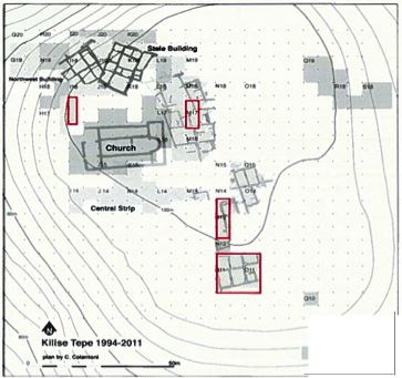
 Fig. 6: Position of 2011 excavation trenches identified by red boxes (Jackson 2011–2012)
Fig. 6: Position of 2011 excavation trenches identified by red boxes. Note the stele building and the northwest building belong to pre-Byzantine phases (C. Colantoni).
Fig. 6: Position of 2011 excavation trenches identified by red boxes (Jackson 2011–2012)
Fig. 6: Position of 2011 excavation trenches identified by red boxes. Note the stele building and the northwest building belong to pre-Byzantine phases (C. Colantoni).
-
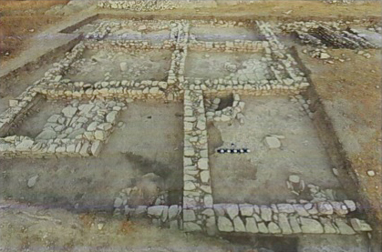
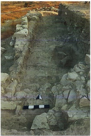
 Fig. 8: Plan of the large building excavated in July 2011 (Jackson 2011–2012)
Fig. 8: Plan of the large building excavated in July 2011 in N12, O12, N11 and O11 (view to south) (Bob Miller).
Fig. 8: Plan of the large building excavated in July 2011 (Jackson 2011–2012)
Fig. 8: Plan of the large building excavated in July 2011 in N12, O12, N11 and O11 (view to south) (Bob Miller).
-
 Fig. 9: Secondary rooms in O11 and O12 (Jackson 2011–2012)
Fig. 9: Secondary rooms in O11 and O12 built against the east side of the structure to the west (view to west) (Bob Miller).
Fig. 9: Secondary rooms in O11 and O12 (Jackson 2011–2012)
Fig. 9: Secondary rooms in O11 and O12 built against the east side of the structure to the west (view to west) (Bob Miller).
-
 Fig. 10: Threshold preserved in wall W5501 in N11a (Jackson 2011–2012)
Fig. 10: Threshold preserved in wall W5501 in N11a (Bob Miller).
Fig. 10: Threshold preserved in wall W5501 in N11a (Jackson 2011–2012)
Fig. 10: Threshold preserved in wall W5501 in N11a (Bob Miller).
-
 Fig. 11: Room in N12d (Jackson 2011–2012)
Fig. 11: Room in N12d (view to east) (Bob Miller).
Fig. 11: Room in N12d (Jackson 2011–2012)
Fig. 11: Room in N12d (view to east) (Bob Miller).
-
 Fig. 12: Collapsed mud brick and stones from walls in O11a (Jackson 2011–2012)
Fig. 12: Collapsed mud brick and stones from walls in O11a (view to east) (Bob Miller).
Fig. 12: Collapsed mud brick and stones from walls in O11a (Jackson 2011–2012)
Fig. 12: Collapsed mud brick and stones from walls in O11a (view to east) (Bob Miller).
-
 Fig. 13: Fire installation FI11/7 (Jackson 2011–2012)
Fig. 13: Fire installation FI11/7 (view from south) (Bob Miller).
Fig. 13: Fire installation FI11/7 (Jackson 2011–2012)
Fig. 13: Fire installation FI11/7 (view from south) (Bob Miller).
-
 Fig. 14: Stone mortars O12/57 and O12/58 (Jackson 2011–2012)
Fig. 14: Stone mortars O12/57 and O12/58, excavated immediately south of W6600 in O12c (Bob Miller).
Fig. 14: Stone mortars O12/57 and O12/58 (Jackson 2011–2012)
Fig. 14: Stone mortars O12/57 and O12/58, excavated immediately south of W6600 in O12c (Bob Miller).
-
 Fig. 15: Lamp chain O11/064 (Jackson 2011–2012)
Fig. 15: Lamp chain O11/064, from destruction deposit in O11a (Bob Miller).
Fig. 15: Lamp chain O11/064 (Jackson 2011–2012)
Fig. 15: Lamp chain O11/064, from destruction deposit in O11a (Bob Miller).
-
 Fig. 16: Partially-reconstructed early Byzantine jar N11/77 (Jackson 2011–2012)
Fig. 16: Partially-reconstructed early Byzantine jar N11/77 with painted decoration, from southwest room of complex in N11 (Bob Miller).
Fig. 16: Partially-reconstructed early Byzantine jar N11/77 (Jackson 2011–2012)
Fig. 16: Partially-reconstructed early Byzantine jar N11/77 with painted decoration, from southwest room of complex in N11 (Bob Miller).
-
 Fig. 17: Working plan of area N14c, N13a, and N13c (Jackson 2011–2012)
Fig. 17: Working plan of area N14c, N13a, and N13c (T. Sutcliffe).
Fig. 17: Working plan of area N14c, N13a, and N13c (Jackson 2011–2012)
Fig. 17: Working plan of area N14c, N13a, and N13c (T. Sutcliffe).
-
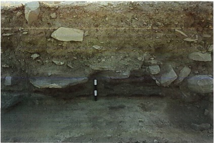
 Fig. 18: I17a (view to north) (Jackson 2011–2012)
Fig. 18: I17a (view to north). Large wall W6700 (running east-west) in foreground and the robber trench (running north) showing its return north. Pit P11/045, to the right of picture, cuts the surface that lay at the base of the wall replaced by robber trench (Bob Miller).
Fig. 18: I17a (view to north) (Jackson 2011–2012)
Fig. 18: I17a (view to north). Large wall W6700 (running east-west) in foreground and the robber trench (running north) showing its return north. Pit P11/045, to the right of picture, cuts the surface that lay at the base of the wall replaced by robber trench (Bob Miller).
-
 Fig. 19: Ash layers on surface against the north and west sides of robber trenches of former walls (Jackson 2011–2012)
Fig. 19: Ash layers on surface against the north and west sides of robber trenches of former walls (view to east, where ash layers run up to robbed east return of robbed wall) (Bob Miller).
Fig. 19: Ash layers on surface against the north and west sides of robber trenches of former walls (Jackson 2011–2012)
Fig. 19: Ash layers on surface against the north and west sides of robber trenches of former walls (view to east, where ash layers run up to robbed east return of robbed wall) (Bob Miller).
-
 Fig. 20: Pit P11/045 (Jackson 2011–2012)
Fig. 20: Pit P11/045. Detail of section through the pit showing burnt wheat (Bob Miller).
Fig. 20: Pit P11/045 (Jackson 2011–2012)
Fig. 20: Pit P11/045. Detail of section through the pit showing burnt wheat (Bob Miller).