Introduction: Site and Work of Past Seasons
Golemo Gradište at the village of Konjuh is the site of an anonymous Late Antique city, located ca. 40 km east of Skopje, on the Kriva River.The location, description, and history of excavation (with full bibliography) of the site has been provided in several earlier articles: C. Snively, "Golemo Gradište at Konjuh: Report on the Excavations in 2000," DOP 56 (2002): 293–302; C. Snively, "Golemo Gradište at Konjuh, Republic of Macedonia: Prolegomena to the Study of a Late Antique Fortification," Niš and Byzantium 4 (2005): 229–44; C. Snively, "Archaeological Excavations on the Acropolis of Golemo Gradište, Konjuh, Kratovo," Macedoniae Acta Archaeologica 18 (2002–04) [2008]: 335–51; C. Snively, "Golemo Gradište at Konjuh: an Unidentified Late Antique City and its Churches," Acta Congressus Internationalis XV Archaeologiae Christianae 2008 (Toledo, forthcoming). Funding in recent seasons has been provided by Gettysburg College, the Loeb Classical Library Foundation, Dumbarton Oaks, and the Ministry of Culture of the Republic of Macedonia. The project is now co-directed by Carolyn S. Snively, Gettysburg College, and Goran Sanev, National Museum of Macedonia. Other staff members in 2009 were Virginia Anderson-Stojanovic, Wilson College, Chambersburg, PA, ceramics analyst; Mihail Stojanoski, archaeologist-curator, Museum of Macedonia; Dejan Georgievski, archaeologist-curator, Kumanovo Museum; Matt Nichols, Cranfield Defence Academy, Swindon (MSc candidate in Forensic Archaeology and Anthropology), archaeologist; Katherine Haas, student at Gettysburg College, architect; and Miroslav Dimovski, photographer, Museum of Macedonia. Now belonging administratively to Kratovo, in antiquity the city stood near the southeast edge of the province of Dardania, whose capital was Scupi (mod. Skopje).I. Mikulčić, Spätantike und frühbyzantinische Befestigungen in Nordmakedonien: Städte, Vici, Refugien, Kastelle (Munich 2002) 22–24. The international project entitled "Archaeological Investigation at Konjuh," sponsored by Gettysburg College in Gettysburg, Pennsylvania, USA, and the Museum of Macedonia in Skopje, Republic of Macedonia, carried out excavations on the fortified acropolis of the site from 2000 through 2004For reports on the investigations on the acropolis, see the first three articles cited in footnote 1., and in the lower town on the northern terrace from 2005 through 2009.A report on the excavations on the northern terrace in 2005 and 2006 will appear in Macedoniae Acta Archaeologica 19 (2010).
Dardania is one of the less well-known Late Antique provinces of the Eastern Empire; it was carved out of Moesia at the end of the 3rd century. The Prefecture of Eastern Illyricum consisted of two dioceses, Dacia to the north and Macedonia to the south. Dardania belonged administratively to the Diocese of Dacia; its ecclesiastical architecture demonstrates northern influence and differs in some respects from that of the province (and Diocese) of Macedonia to the south.
The site consists of a long, east-west ridge or acropolis, rising 100 meters above the level of the Kriva river to a height of ca. 440 m above sea level; a broad, gently sloping terrace between the northern foot of the acropolis and the Kriva River; and a narrow and as yet unexplored area below the south side of the acropolis. The Rotunda, a unique early Byzantine church, is located outside the fortified city, ca. 250 meters to the south. The investigation of the acropolis led to the conclusion, briefly summarized, that a fortress was constructed there in the second quarter of the 6th century and that intensive activity, characterized by rebuilding after destruction, continued until the end of that century or the beginning of the 7th. At least one destructive event was an earthquake, as indicated by the collapse of a fountain house into the cistern it had once sheltered.Numismatic evidence is very sparse; the ceramic dating suggests that the earthquake was later in the 6th century than the one described by Marcellinus Comes in the province of Dardania in 518. Although some 4th- and 5th-century pottery and prehistoric material was found, ceramics analyst Virginia Anderson-Stojanović points to the overwhelming quantity of 6th-century pottery as evidence for a Justinianic date for the landscaping and fortification of the acropolis.
In 2005 investigations began on the northern terrace, in the lower town. A settlement with northern exposure suffers from obvious disadvantages. But location on a terrace surrounded on three sides by a river and next to a naturally defensible acropolis, providing refuge in time of need, would have looked increasingly attractive in Late Antiquity. Parts of several city blocks have been excavated on the terrace, and a pilot geophysical survey was carried out in summer of 2008. A view of the urban layout, although still incomplete or unverified, has begun to emerge.
The lower city on the northern terrace was constructed during the second half of the 5th century and substantially rebuilt in the 6th, perhaps contemporary with the construction of the fortress on the acropolis in the second quarter of that century. Possibly the residents of the lower city fled to the acropolis for refuge in the later 6th century. The latest levels on the terrace have been removed by erosion or other factors, but scattered burials and foundations of structures with a new orientation suggest at least partial abandonment. The acropolis fortress itself was heavily damaged or destroyed at the end of the 6th or the beginning of the 7th century.
")
A limited number of new cities were built in Late Antiquity, and in most instances they were constructed for fairly specific reasons.E. Zanini, "The Urban Ideal and Urban Planning in Byzantine New Cities of the Sixth Century AD," in L. Lavan and W. Bowden, eds., Theory and Practice in Late Antique Archaeology (Leiden 2003), 196–223. The settlement at Golemo Gradište was the only urban settlement among a line of fortresses that guarded a section of road running through the valley of the Kriva River on its way from Scupi (Skopje) to Serdica (Sofia) in Bulgaria.See now the preliminary report on excavations at Klečovce, in the Kriva valley west of Konjuh: Z. Nikolovski, "Crvkište-Ramnište, s. Klečovce, Kumanovsko. Istražuvanje 2001-2004 godina," Macedoniae Acta Archaeologica 18 (2002–04) [2008]: 323–33. The region was in antiquity and remains a mining region, described today as having low-grade iron ore. It experienced intensive occupation in Late Antiquity. The creation or the increased importance of the road through the Kriva valley, the series of fortresses overlooking that road, and the construction of the city at Golemo Gradište in the 5th century and strengthening of its defenses in the 6th century—all these developments in eastern Dardania probably reflect the increased importance of the mineral resources in that region. The strategically placed city at Golemo Gradište would have served as a secondary administrative center in eastern Dardania and would have controlled mining activities in the region.
Svetozar Radojčić visited the site at Konjuh in July 1938 and published his observations in 1952.S. Radojčić, "Crkva u Konjuhu," Zbornik Radova Vizantološkog Instituta 1 (1952): 148–67. Although the article focused primarily on the Rotunda (and fortunately provides much information now lost), the investigator mentioned the fortification wall, the "hermitage" on the acropolis, a bridge, the medieval church, and a large basilica. He noted that the contours of the church were visible on the surface and that a pile of broken fragments of white marble architectural sculpture lay in the area of the presbyterium.Ibid., 149.
In the early 1970s, Ivan Mikulčić studied the topography of the site at Konjuh. He also mentioned the remains of a large basilica in the central part of the northern terrace, but pointed out that since Radojčić had visited the site, the villagers had dug out and removed the greater part of the architectural fragments, in particular a number of screen slabs decorated with crosses.I. Mikulčić "Anticki gradovi kod Drenova i Konjuha u Makedoniji," Arheoloski Pregled 15 (1973): 179–82.
One of the goals of our excavations in the lower town was to find the church mentioned by the earlier investigators. It was not visible on the surface, however, even from the acropolis. Excavation in the spot indicated by comparison of our plan of the terrace with Mikulčić's plan showing the location of the basilica revealed a block of residences. Conversations with villagers who remembered the removal of architectural blocks from the terrace pointed to a variety of contradictory locations for the church. As the members of the project became more involved with questions of urbanism raised by excavation on the terrace, the basilica receded into the background.
In June 2008, a section of a curved wall appeared at the west end of Trench 35, only 0.15–0.20 m below the surface. Limited excavation, carried out in the church during that season, revelaed the apse and the space east of the apse, the east end of the north aisle, and a section across the south aisle. The results of the 2008 investigations are summarized briefly.
")
The curved wall to the east of the apse has been interpreted as a terrace wall. Robbers’ trenches damaged it at both ends, but it would have provided space for access to the eastern entrances of both the north and south aisles.
The north wall of the church was built over earlier unidentified structures. The east end of the aisle was filled with very heavy stone debris or, as we later speculated, with a deliberate stone packing, from the level of the preserved top of the east and north walls down to the only floor level of beaten earth. Steps led down into the aisle from the doorway whose bottom was preserved in the east wall. The floor lay ca. 70 cm below the floor levels in the presbyterium and the south aisle and thus left a number of unanswered questions about the north aisle.
")
The apse and a narrow slice of the presbyterium were investigated in Trench 39. The arrangement of the apse is relatively simple but shows unusual features. Within the apse, at a distance of ca. 0.70 m from the inner face of the apse wall, a stone and mortar construction was built, thus creating a ca. 0.70 m wide corridor, a kyklion, between the apse wall and the inner construction. This construction extends ca. 0.70 m to the west beyond the ends of the apsidal wall. At the middle of the west face of the construction, two large stone blocks form steps that give access from the presbyterium into the construction in the apse. It is probable that a third block, now missing, formed a third and higher step toward the east.
")
On axis with the steps and just east of them, a small rectangular chamber, 2.10 x 0.80 x 0.90 m high, is located within the construction in the apse toward its east side. This chamber, opening into the corridor, is identified as a tomb or a crypt. The floor of the chamber (W348.90, E348.94) and the packed earth floor of the corridor (348.91/349.01) lie at approximately the same level as the top of the foundation of the apse wall and the bottom of the apse wall proper. It appears that the apse wall, the antae, and the construction in the apse, along with the tomb/crypt, were all built together, presumably as part of the first phase of the church. A narrow ledge, 0.10–0.15 m wide, is preserved at the north and south sides of the tomb/crypt, 0.90 m above its floor; a slab or slabs would have rested on the ledges and would have formed the cover of the crypt. Since no features are preserved above this level, we can only speculate about the location of the bishop’s throne, given the assumption that this church was the main church of the city and an episcopal seat.
The floor of the presbyterium consists of a hard gray-white mortar with pebbles. There is no evidence to suggest that the mortar surface was covered with mosaic or stone slabs or bricks. The mortar floor also appeared in front of the south end of the corridor, beside the east end of the south synthronon. The floor appears to run under the lowest step of the south synthronon.
")
Lateral synthrona or clergy benches constructed of stone blocks demarcate the north and south sides of the presbyterium. The southern one is better preserved, at least at the east end, where three steps remain in situ. The south synthronon clearly blocked the entrance to the apsidal corridor, which had been filled with dark-colored earth and stones; a reused block, perhaps supporting a small column, stood in the space between the synthronon and the corridor. Thus it appears, in the present state of investigation, that the synthrona belonged to a second phase or a renovation when the corridor had ceased to function.
The corridor or kyklion in the apse is somewhat unusual, but similar features are found elsewhere, primarily in the provinces of Macedonia and Epirus.The kyklion is related in function to the apsidal crypt found in churches in Stobi and Thessaloniki and elsewhere; see C. Snively, "Apsidal Crypts in Macedonia: Possible Places of Pilgrimage?" Jahrbuch für Antike und Christentum, Ergänzungsband 20.2 (1995): 1179–84; and "A Type of Underground Cult Place from Late Antiquity: How did it Function?" in Early Christian Martyrs and Relics and their Veneration in East and West, International Conference, Varna, 2003 (Varna, 2006), 163–72. For the kyklion specifically, see A. Orlandos, Η ξυλόστεγος παλαιοχριστιανική βασιλική της μεσογειακής λεκάνης (Athens, 1952–57), 493–95; and, more recently, I. D. Varalis, "Τα χαρακτηριστικά της εκκλησιαστικής αρχιτεκτονικής της Νικόπολης: παραλληλίες και διαφοροποιήσεις," in Νικόπολις Β’, Πρακτικά του Δευτέρου Διεθνούς Συμποσίου για τη Νικόπολη (11–15 Σεπτεμβρίου 2002), ed. K. Zachos (Preveza, 2007), 1:598–99, and especially note 31. Its closest parallel, however, is nearby, in the Rotunda church at Konjuh. The Rotunda, excavated by local villagers in 1919, stood south of the city. In 1938 Svetozar Radojčić documented many features of the Rotunda that no longer exist. One such feature was the blind corridor in the apse. As one of Radojčić's photographs shows, a wall closed the west side of the apse. In the middle was a staircase, and the entrance to an annular corridor is visible at the south end.Radojčić, "Crkva," fig. 12. The corridor in the Rotunda was blind, i.e., closed at the north end. Similarities in the apsidal arrangements of the two churches include the small rectangular spaces at the ends of the corridor, the latter feature formed in both churches because the construction in the apse extends to the west beyond the ends of the apsidal wall. In both buildings, steps centered at the front of the construction in the apse led up into the apsidal space where, presumably, the throne of the bishop or presiding clergyman stood.
The 2009 Season
Determining the length of the basilica and its overall plan was one of the primary goals of excavation in summer of 2009. Although the ca. 15 m wide structure appeared to be divided into a nave and two lateral aisles, the arrangement of the colonnades and their supporting stylobates was not clear. The clearance of the presbyterium and the determination of its layout was a second major goal. Given the apparent importance of the building and thus the need for its eventual complete investigation, the third goal was to excavate as much of the nave and south aisle as possible in a scientific and responsible way. Therefore three areas of the church were investigated in 2009: the south aisle (Trenches 46 and 47), the presbyterium (Trench 45), and the narthex and annex rooms at the southwest corner of the building (Trenches 44 and 48). The situation in the presbyterium and part of the south aisle, where a large number of fragments of smashed architectural blocks came to light in complicated stratigraphy, slowed the work down somewhat, but the plan of the entire east end of the church and of part of the narthex together with an annex room located south of the narthex has now been revealed.
Trenches 44 and 48 at the Southwest
Excavation was carried out in this area in order to define the west end of the church complex. The ground slopes gently down from south to north (elevation 351.56 masl at south side of Trench 44, 350.35 at north edge of Trench 48), and the trenches lie north of and below a steep bank that probably conceals a supporting wall that divided two terraces. The initial 2 x 5 m test trench placed in this area came down directly on top of a north-south wall (Wall 1) that turned out to be the west wall of the first annex room (Room 1) to the south of the narthex. Trench 44 was then extended to the east; its final dimensions were 5 m north-south x 6 m east-west. After it became clear that Trench 44 lay to the south of the basilica proper, a second trench, Trench 48 (6 x 6 m) was opened 1 m to the north of Trench 44. The two trenches together revealed a) the southern end of the narthex; b) the entire interior space of annex Room 1; c) the northern end of a second annex room (Room 2) located south of Room 1, and including a grave; d) walls running west from the narthex and annex rooms, probably belonging to an atrium; and e) earlier walls and features below the floor level of Room 1.Room 1 had interior dimensions of 4 m east-west; its length along the west wall was 4.8 m, along the east wall 4.4 m. Walls 1 (west), 2 and 4 (south), 5 (east), and 8 and 9 (north) enclosed the room. Room 2 had interior dimensions of at least 5.5 x 1.20 m; its extent to east and south is unknown.
Several modern disturbances or illegal trenches were noted in this area; in fact, the entire central portion of Trench 48 had been dug to a depth of ca. 1.25 m and the stratigraphy had been seriously disturbed. In Trench 44, below the surface layers, two deposits of debris, mostly stones and chunks of mortar in light brown earth, covered the trench; they represent two stages in the collapse of the walls of the room. Below the wall debris, a layer of roof tiles covered Room 1 and continued across the threshold into Room 2 to the south. A second layer of roof tiles, which included several smashed but complete examples and a number of vertically fallen tiles, represents the first stage of collapse of the roof, probably when a roof beam near the doorway between the two annex rooms broke. No evidence of fire was noted.
The 10–20-cm-thick deposit of earth below the roof tiles represents a period of abandonment, probably accumulating after the building ceased to function and had been stripped of floor material, doors, and windows, but before the roof collapsed. This deposit extended to the north into Trench 48, where it was the first relatively undisturbed layer. The situation in Trench 48, i.e., in the narthex of the basilica, differed from the situation in Trench 44. In Trench 48 the layer of abandonment, deposited by wind and water, covered a layer of roof tiles, which lay on a compact earthen surface at elevations 349.05/349.11 masl.
In Trench 44, the removal of the silty layer (abandonment) revealed a stone and mortar built step in Room 1, just below and north of the threshold block of the doorway between Walls 2 and 4. A mortar floor was preserved in the southwest corner of Room 1 (elevation 349.94 masl). A doorway between Wall 4 and the south end of Wall 5 provided access to a space to the east of Room 1, perhaps another annex room, as yet unexplored. The removal of the silty layer revealed the tops of two parallel and adjoining walls, Walls 6 and 7, that ran across Room 1 below the level of its (missing) floor.Wall 6, the southern one, was constructed of stones and lime mortar; the use of lime mortar is characteristic of all the basilica walls. Wall 1 cuts Wall 6 at the west side of Room 1; the south end of Wall 5 rests on the top of Wall 6. Wall 7, the northern one, was built of stones bonded with clay; both Walls 1 and 5 cut Wall 7. The relationship between Walls 6 and 7 remains unclear, although Wall 7 is assumed to be earlier.
")
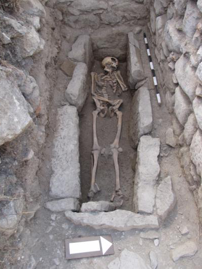
In Room 2, Grave 1 (2009) occupied the entire excavated area in the northwest corner of the room. It consisted of three sandstone slabs along north and south sides of the grave and another slab at east and west ends. Six irregularly shaped cover slabs lay across the top of the grave. The interior was filled with a light brown earth that had probably filtered in through the gaps among the cover slabs. The skeleton was an adult male, ca. 1.6 m tall, who was between 35 and 45 years old at his death.The skeleton was examined at the site by Charlotte Maxwell-Jones, graduate student at the University of Michigan and a member of the Konjuh staff in previous seasons, who visited the site briefly in late July. A healed fracture of the left femur suggests that the man would have limped, perhaps quite badly. The only associated artifact was a small bronze cross, found in the chest area.
")
The southern 5 m of the narthex, whose east-west interior width was ca. 4 m, were investigated in Trench 48. Walls 8 and 9 formed the south end of the narthex; a doorway between them gave access to Room 1. Wall 9 bonded with Wall 10, which together with Wall 12 formed the east wall of the narthex; a doorway between Walls 10 and 12 gave access to the south aisle of the basilica. Wall 8 bonded with Wall 11, which together with Wall 16 formed the west wall of the narthex; a doorway between Walls 11 and 16 gave access to the exterior or to an atrium. Walls 10, 11, and 12 display impressions of bricks in the mortar surfaces of their preserved tops; the bricks were robbed from the walls in relatively modern times. Walls 11, 8, 9, and 10 form the unified south end of the narthex; Wall 9 (= Wall C6) continues to the east as the south wall of the south aisle of the basilica. These walls are bonded and display similar construction with high-quality lime mortar. Walls 1 and 5, the east and west walls of Room 1, abut Walls 8 and 9 respectively, but do not bond with them and display different construction (e.g., no bricks, poor-quality mortar) than the walls of the basilica proper. One may conclude that the nave, aisles, and narthex of the basilica were constructed first and the southern annex rooms were added somewhat later.
Because of limited time at the end of the season, only the western half of the narthex was dug to possible floor level in Trench 48. As noted above, the layer of abandonment could be traced through the removal of the baulk between Trenches 44 and 48 into the latter trench; it rested above a deposit of roof tiles that lay over a compact earthen layer. A narrow wall or barrier, Wall 14, apparently rested on the compact earth and marked off the southwest corner of the narthex. The most puzzling aspect of Rooms 1 and 2 and the south end of the narthex is the lack of a real floor. This issue will be discussed again below in connection with Trench 46 in the east end of the south aisle.
Excavation in Trenches 44 and 48 allowed us to determine the length of the basilica as ca. 33 m, from the east face of the apse wall to the west face of the west wall of the narthex. As is fairly standard in early Byzantine basilicas, at least two and probably more annex rooms were located to the south of the narthex. Given the intramural location of the church, the possibility of an atrium is not surprising.
East End of the South Aisle
Two trenches were dug in the south aisle in 2009; Trench 46 was located to the east of Trench 40, dug in 2008, while Trench 47 lay to the west of Trench 40. The purpose of Trench 46 was to define the east end of the aisle. Its dimensions were ca. 4.5 m east-west x ca. 4 m north- south at its widest point. The surface of the trench sloped down gently from south to north and from east to west (beginning elevations: NE 350.64, NW 350.45, SE 350.82, SW 350.58).
Disturbed areas were noted, especially along the line of the south wall of the aisle (Wall C6), where the layer of mortar on the preserved top of the wall shows impressions of bricks. Here again it seems likely that the bricks were removed in relatively recent times. The illegal trench found last year in the north end of Trench 40 and in the southwest corner of Trench 39 also extended into the northwest corner of Trench 46.
Apart from disturbed and illegally excavated areas, the stratigraphy within the east end of the aisle was fairly simple. Below the surface deposit, a deposit of loose brown earth, relatively light in color because of mortar dust and mortar lumps, appeared. It included many large stones across the entire area on top of the deposit, but further down large stones were found only near the east wall while small and medium size blocks appeared in the rest of the trench. Small fragments of roof tiles and bricks were also noted. The deposit of debris continued with minor variations down to a compact, darker brown deposit with ashy intrusions and no debris (elevation ca. 349.07 masl).
A doorway was located in the east wall of the basilica, in an unusual position, at the north end of the east wall, immediately south of the anta.The doorway noted in 2008 at the east end of the north aisle was also located toward the south end of that wall; no threshold was found in situ, and the certain existence of the doorway was demonstrated only by the steps inside the aisle. It is possible that this doorway was also situated beside the anta. It was 0.95 m wide. A threshold block at elevation 349.54 masl occupied the east side of the doorway. Eastern entrances may appear to north or south of center, but there is no other obvious example of a doorway at the corner of an aisle. Structural concerns would dictate a position near the middle of the east wall of an aisle. It should be noted that numerous large stone blocks were employed in the anta and the east wall to strengthen that part of the church.
")
Ca. 0.60 m to the west of the doorway, a bench 0.50 m wide and 1.50 m in length rested against the south face of the "stylobate" wall.In fact, this is not a stylobate wall but apparently the south side of the synthronon. Another feature was located immediately south of the doorway; now poorly preserved, it probably once extended into the southeast corner of the aisle. Ca. 0.50 m east-west, it consisted of frame of stone blocks at north and west with a rough stone paving in the interior. In the limited space just inside the doorway, a patch of rough kaldrma paving was found at elevation 349.20 masl.
The compact dark brown deposit that appeared below the debris is being interpreted as either the floor of the aisle or the earthen foundation for a floor. It should be noted that no layer of roof tiles appeared above this darker deposit. A stone ledge or foundation was noted along the interior of the south wall at a similar elevation (349.04) with one possible stone paving slab resting on the foundation (349.14). A test pit dug in the southeast corner of the aisle revealed more of the foundation along the south wall as well as the foundation of the east wall; the amount of pottery and animal bones indicated pre-basilica levels.
Limited excavation outside the southeast corner of the basilica indicated that the floor level outside the east aisle lay at elevation 349.34 masl, although a ledge or foundation along the exterior face of the east wall appeared at 349.56.
Excavation in the Presbyterium
")
The excavation of Trench 45 in the presbyterium revealed a complicated stratigraphical situation. In addition to one obviously recent hole toward the south side, which had gone through the floor of the presbyterium, other disturbances were observed below the surface deposit.Given the fact that the outline of the basilica was discernible in the 1970s, and that some walls appeared only 15–20 cm below the modern surface, we conclude that the surface deposit was deposited by erosion within the last few decades.
")
Broken fragments of architectural blocks were found in heaps, apparently tossed aside as unusable by those digging through the debris in search of building material. In some parts of the presbyterium, however, screen slabs were found, as they had fallen onto an ashy deposit above the floor. A large hole marked the location of the altar, of whose foundation only the northern part was preserved; no trace remains of a space for a reliquary. Several large blocks and two short pieces of wall had been placed on top of a shallow layer of debris, but they formed no visible pattern or structure. Despite the series of intrusions, the chancel screen base was entirely preserved together with at least the foundations for the lateral clergy benches or synthrona and the completely unexpected base of a small ambo within the presbyterium.Other examples are found at Philippi, where two ambos, one each in the presbyterium and in the nave, were found in both the Octagon church and the Museum Basilica. See G. Gounaris, "Le problème de l'existence de deux ambons dans l'Octogone de Philippes," in Actes de Xe Congrès International d'Archéologie Chrétienne, Thessalonique 1980 (Thessaloniki and Vatican City, 1984) 2:133–40; E. Kourkitidou-Nikolaïdou, "Les ambons paléochrétiens à Thessalonique et à Philippes," Corsi di cultura sull'arte ravennate e bizantina 31 (1984): 255–75. For two ambos in the church of Ayia Sophia in Thessaloniki, see Ch. Bakirtzis, "The Urban Continuity and Size of Late Byzantine Thessalonike," DOP 57 (2003): 51–52 (with bibliography).
Trench 45 offered evidence for a complicated sequence of destruction of this part of the building. Our present interpretation is that the basilica was abandoned and probably stripped of some of its furnishings; the relic may have been removed from below the altar at that time. A limited destruction by fire followed, during which screen slabs from the chancel screen fell onto a layer of ash on the floor. What happened to the roof is unclear, since only scattered and fragmentary roof tiles were found in the presbyterium. Some of the superstructure collapsed to cover the chancel screen base before the large blocks and pieces of wall were placed above it. After more of the walls fell but probably still in antiquity, people dug through the debris to remove usable architectural material and threw unwanted fragments aside. More recently, undoubtedly in part during the 20th century, people again dug through the debris, as far as the floor of the presbyterium; several pieces of screen slab that showed evidence of having lain in the ashy layer above the floor were found in disturbed areas just below the modern surface. Debris from Wall C6, the south wall of the south aisle, and from the walls of the narthex suggest that the upper part of those walls was also destroyed in the 20th century in order to rob the bricks whose impressions are still visible in the mortar on the preserved top of the walls.
The construction of this church can be dated to the 6th century, and probably to the second quarter or mid-6th century, although the total lack of coins and the extremely sparse ceramic material means that date is based on architectural sculpture and on the place of the basilica within the phases of building in the lower city. Evidence for changes or renovation can be seen in the church, e.g. the apparent blocking of the ambulatory corridor in the apse by the lateral synthronon. This basilica was possibly constructed above an earlier and smaller church. The central location on the terrace suggests that the basilica was the main church of the city. The size of the city and the existence of at least two substantial churches, moreover, points to the site having been a bishopric.
The early Byzantine ecclesiastical architecture of the province of Dardania is not well known. A new basilica was discovered at Scupi in 2008; the discovery of two churches in major cities of the province is providing new evidence.
The presbyterium of the basilica at Konjuh is quite large. The overall width of the church is almost 15 meters. The side aisles are narrow relative to the wide nave, and the presbyterium takes up most of that width, ca. 7 meters. The length of the nave is ca. 24 m, of which the presbyterium—without the entrance—occupies ca. 8 m or about a third. Other churches in Dardania have wide naves and narrow side aisles, but the oversized presbyterium at Konjuh stands out.
")
Investigation in the south aisle has explained to some extent why in 2008 stylobate walls could not be traced to the west of the antae at the corners of the apse. Approximately 4 m west of the anta on either side of the church stands the base of a built pier, 1.00 x 0.60 m; ca. 2 m further west a column base marks the beginning of a colonnade.Although future excavation could change the present view, it appears that one large arch spanned the distance between the anta and the pier, without an intervening column. Such an arrangement has been noted in a number of churches in the Balkan Peninsula, often associated with a transept or pseudo-transept; in most examples the pier supporting the west end of the arch was located near the west corner of the presbyterium. In this basilica at Konjuh the presbyterium was apparently too long to be spanned by a single arch, so that the pier was located beside the presbyterium rather than at its west end. Orlandos, Η βασιλική, 169–89, provides a number of church plans with piers at the west side of the presbyterium; he identifies all of them as having transepts. Varalis, Τα χαρακτηριστικά, 600–01, arguing against the views of D. Pallas (for whom he provides copious bibliographical references), discusses the piers briefly as he attempts to show that the spaces at the east end of the aisles in the churches at Nikopolis were not necessarily transepts. For a discussion of two churches with such piers that clearly did not have transepts, the Museum Basilica at Philippi and the Episcopal Basilica on the Terrace at Stobi, see C. Snively, “Transepts in the Ecclesiastical Architecture of Eastern Illyricum and the Episcopal Basilica at Stobi,” Niš and Byzantium 6 (2008): 59–74 (with bibliography). A gap 0.70 m wide between the west end of the lateral synthrona and the chancel screen base on both north and south sides provided access to the presbyterium from the side aisles, just to the east of the piers.
")
An amazing number of fragments of architectural blocks was found in the presbyterium and in the north side of Trench 47 in the south aisle: pieces of large and small columns, bases, impost capitals, screen slabs, and blocks of unidentified function. Some very fragmentary curved slabs decorated in relief show similarities to sculpture found in the Rotunda and identified as belonging to the ambo in that church.Petrov, K., “Rekonstrukcija na ambonot od rotondata vo Konjuh,” Godišen Zbornik na Filozofski Fakultet, Skopje 22 (1970): 271–302. A broken but almost completely preserved slab with a peacock represented in relief belongs to the staircase of an ambo. We assumed that these slabs came from the small ambo in the presbyterium until several joining fragments of a thick round block, probably from a much larger ambo, were found at the west end of Trench 47. They suggest that a second ambo once stood in the nave of the basilica.
")
Despite the plethora of robbers’ trenches and heaps of spoil dirt, the basilica on the northern terrace at Golemo Gradište, village of Konjuh, although only excavated in part, is preserved in plan and shows a number of interesting and unusual features. Some of the decorated architectural fragments are of marble, but the relief panels of the ambo are cut from local stone. The sculpture from the ambos, both from the new basilica and from the Rotunda, is apparently without parallel in Dardania.More research is needed here; Jean-Pierre Sodini, who has been interested in our site for a long time precisely because of the sculpture from the Rotunda ambo, has provided some suggestions to follow up. The large size of the presbyterium, the arrangement of the colonnade with built piers appearing beside the presbyterium, the small ambo within the presbyterium, and the odd placement of the eastern entrance(s)—all these features suggest that more was happening ecclesiastically in the southeast corner of Dardania in the 6th century than previously imagined. The excavation of the rest of the basilica complex may provide some answers to the questions posed by results of the investigations till now.
")
-
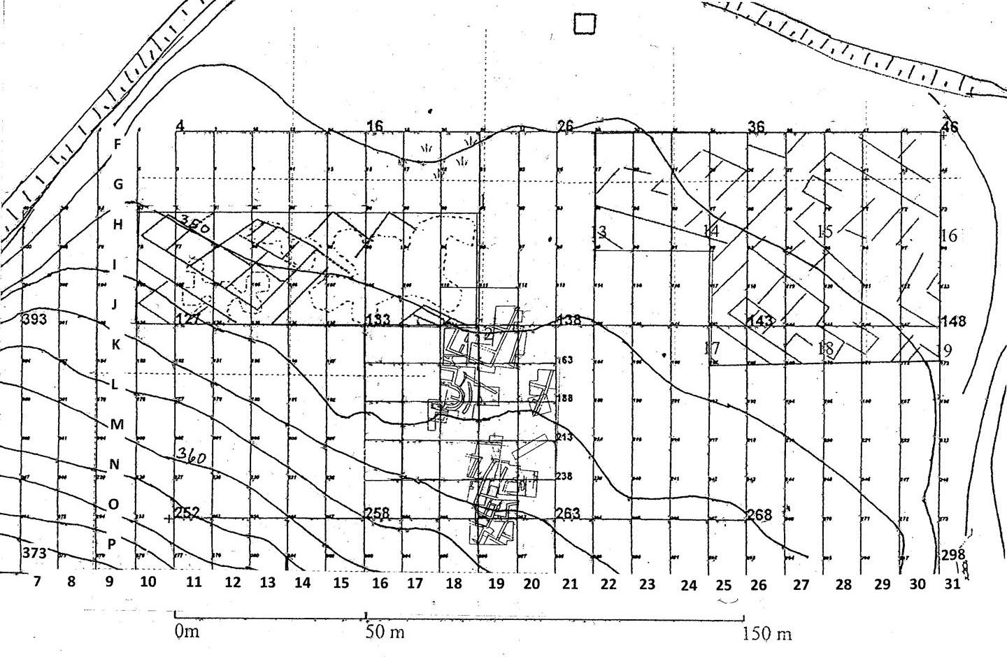
 Fig. 2: Plan showing the excavated areas on the terrace and the results of geophysical scanning (Snively 2009–2010)
Fig. 2: Plan showing the excavated areas on the terrace (in the middle) and the results of geophysical scanning (upper left and right). The apse of the church appears in grid squares L/M18
Fig. 2: Plan showing the excavated areas on the terrace and the results of geophysical scanning (Snively 2009–2010)
Fig. 2: Plan showing the excavated areas on the terrace (in the middle) and the results of geophysical scanning (upper left and right). The apse of the church appears in grid squares L/M18
-
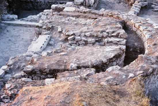
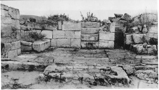
 Fig. 3: Curved terrace wall, east of the apse (Snively 2009–2010)
Fig. 3: Curved terrace wall, east of the apse.
Fig. 3: Curved terrace wall, east of the apse (Snively 2009–2010)
Fig. 3: Curved terrace wall, east of the apse.
-
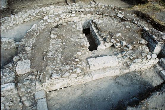
 Fig. 4: Apse wall and stone-and-mortar construction (Snively 2009–2010)
Fig. 4: Apse wall and stone-and-mortar construction. Note the wide corridor (kyklion) between.
Fig. 4: Apse wall and stone-and-mortar construction (Snively 2009–2010)
Fig. 4: Apse wall and stone-and-mortar construction. Note the wide corridor (kyklion) between.
-
 Fig. 5: Crypt or tomb, located within the construction in the apse (Snively 2009–2010)
Fig. 5: Crypt or tomb, located within the construction in the apse.
Fig. 5: Crypt or tomb, located within the construction in the apse (Snively 2009–2010)
Fig. 5: Crypt or tomb, located within the construction in the apse.
-
 Fig. 6: South synthronon (Snively 2009–2010)
Fig. 6: South synthronon.
Fig. 6: South synthronon (Snively 2009–2010)
Fig. 6: South synthronon.
-
 Fig. 7: Blind corridor in the apse of the Rotunda church, photographed in 1938 by Svetozar Radojčić (Snively 2009–2010)
Fig. 7: Blind corridor in the apse of the Rotunda church, photographed in 1938 by Svetozar Radojčić.
Fig. 7: Blind corridor in the apse of the Rotunda church, photographed in 1938 by Svetozar Radojčić (Snively 2009–2010)
Fig. 7: Blind corridor in the apse of the Rotunda church, photographed in 1938 by Svetozar Radojčić.
-
 Fig. 8: Grave 1 in Room 2, with the skeleton of an adult male (Snively 2009–2010)
Fig. 8: Grave 1 in Room 2, with the skeleton of an adult male.
Fig. 8: Grave 1 in Room 2, with the skeleton of an adult male (Snively 2009–2010)
Fig. 8: Grave 1 in Room 2, with the skeleton of an adult male.
-
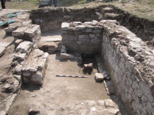
 Fig. 9: Trench 48 (Snively 2009–2010)
Fig. 9: Trench 48.
Fig. 9: Trench 48 (Snively 2009–2010)
Fig. 9: Trench 48.
-
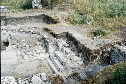
 Fig. 10: From the east end of the south aisle (Snively 2009–2010)
Fig. 10: From the east end of the south aisle.
Fig. 10: From the east end of the south aisle (Snively 2009–2010)
Fig. 10: From the east end of the south aisle.
-
 Fig. 11: Plan of apse and presbyterium (Snively 2009–2010)
Fig. 11: Plan of apse and presbyterium.
Fig. 11: Plan of apse and presbyterium (Snively 2009–2010)
Fig. 11: Plan of apse and presbyterium.
-
 Fig. 12: Presbyterium (Snively 2009–2010)
Fig. 12: Presbyterium.
Fig. 12: Presbyterium (Snively 2009–2010)
Fig. 12: Presbyterium.
-
 Fig. 13 (Snively 2009–2010)
Fig. 13.
Fig. 13 (Snively 2009–2010)
Fig. 13.
-
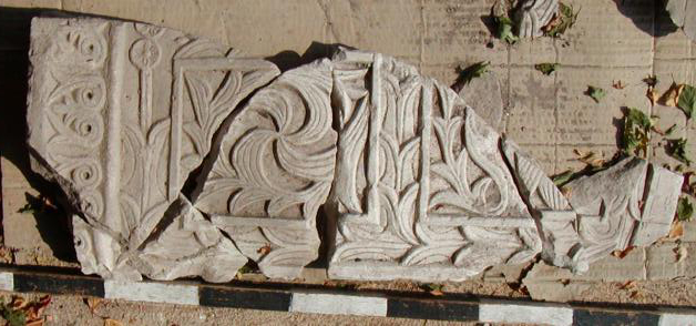
 Fig. 14: Part of a decorated slab from the ambo (Snively 2009–2010)
Fig. 14: Part of a decorated slab from the ambo.
Fig. 14: Part of a decorated slab from the ambo (Snively 2009–2010)
Fig. 14: Part of a decorated slab from the ambo.
-
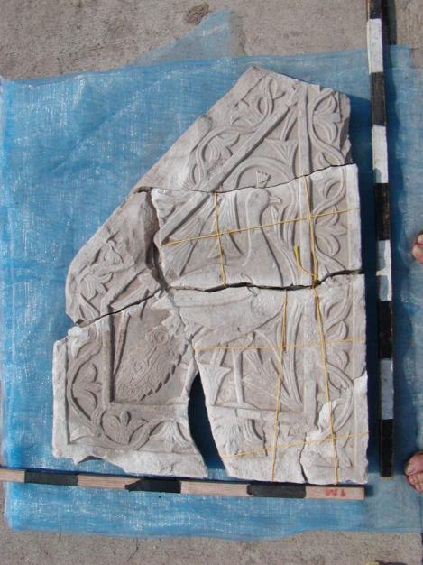
 Fig. 15: Slab with representation of a peacock, from the staircase of an ambo (Snively 2009–2010)
Fig. 15: Slab with representation of a peacock, from the staircase of an ambo.
Fig. 15: Slab with representation of a peacock, from the staircase of an ambo (Snively 2009–2010)
Fig. 15: Slab with representation of a peacock, from the staircase of an ambo.
-
 Fig. 16: Parts of the round block thought to be from a large ambo in the nave (Snively 2009–2010)
Fig. 16: Parts of the round block thought to be from a large ambo in the nave.
Fig. 16: Parts of the round block thought to be from a large ambo in the nave (Snively 2009–2010)
Fig. 16: Parts of the round block thought to be from a large ambo in the nave.