Introduction
Cerro Narrío is an iconic site in the archaeological accounts of the prehistory of Ecuador. Situated in the southern highlands of Ecuador, adjacent to an expanding community, it is in immediate risk of destruction.
Max Uhle (1922) first brought Cerro Narrío to the attention of archaeologists internationally following his archaeological explorations in the southern highlands of Ecuador during the early 1920's. Uhle did not carry out excavations at the site but noted the large quantities and great variety of fine ceramics that had been looted from it. Since then, Cerro Narrío has been looted periodically—especially during the holy week of Semana Santa. In addition to fine pottery reported by Uhle, carved spondylus shells, gold ornaments, and obsidian are reputed to have been recovered from the site. Following Uhle's visit, the only archaeological investigation of the site was made in the early 1940's by Donald Collier and John Murra, of the Field Museum in Chicago. Their excavations yielded a relative chronology for the site, which they divided into two broad periods, Early Cerro Narrío and Late Cerro Narrío (Collier and Murra 1943). The calendrical ages of these two periods have not been established and remain a source of controversy among archaeologists. (Braun 1982; Bruhns 1989, 2003; Bruhns et al. 1990; Lathrap et al. 1975) A charcoal sample, collected in the 1970's from the site but lacking exact provenience, yielded a radiocarbon date in the third millennium BC. Although some archaeologists rightly question the reliability of this date, it may mark the beginning of the occupation at Cerro Narrío. If so, the site continued to be occupied, perhaps intermittently, until late Prehispanic times, and was possibly a major political and cultural center of the Cañari people when the Incas began their conquest of Ecuador in the 16th Century AD.
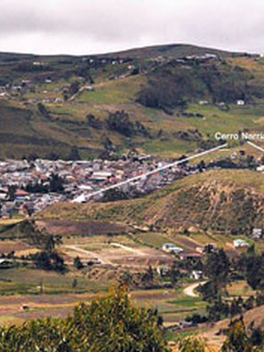

The recent urban expansion of Cañar poses the largest and most immediate threat to Cerro Narrío. In the past few years, local developers purchased land skirting the eastern and northeastern flanks of the hill and, began digging trenches for water service, sewage and electricity.
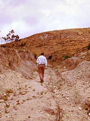
When we arrived on the site last year (2007), we discovered that excavations for some house foundations had been completed and that several houses were in the process of construction. Through questioning of the developers and of officers of the Instituto Nacional de Patrimonio Cultural (INPC), we discovered that archaeologists in the employ of the INPC had given the go-ahead to the developers, saying that there was no evidence of prehistoric cultural remains on the land in question. Our preliminary excavations in 2007, however, had proved otherwise. The site does indeed extend onto the flatter land flanking the hill to the east and northeast. On our arrival in Cañar this year, we were pleased to find that the INPC, based on our preliminary findings, had asked the developers to temporarily cease construction and that the developers had complied.
The Cañari farmsteads pose a lesser threat to the site in that construction is on a much smaller scale. The Cañaris, however, are constructing new houses, much more substantial than their previous dwellings, and also make use of the hill itself for tethering pigs and grazing sheep. The townspeople and, to a much lesser extent, the Cañaris make use of the main part of the site for recreation-flying kites, picnics, love-making and digging for treasure. Many of the Cañaris still hold reverential feelings toward Cerro Narrío, as a locale associated with their ancestors. These feelings, ironically, are partly responsible for much of the former destruction of the site. According to local accounts, much of the looting took place at the urging of the local priests with the aim of physically destroying the heathen iconography of the Prehispanic era.
Goals and Results
Our goals for 2008 were:
- To complete and expand our excavations from last year on the land being developed for housing in order to determine whether the site extended beyond the flanks of the hill and to recover evidence that would be convincing to both the municipality of Cañar and the INPC.
- To try to discover more undisturbed areas on the hill, where looting has been carried out for more than 80 years, and excavate in those areas. Our goal being to determine whether there is enough remaining of that part of the site to warrant larger scale excavations which might resolve controversies regarding the age and function of the site.
- To identify the disturbed areas in detail on our topographic map.
- To enlist the support of the Cañaris, the municipality, and the INPC in protecting the site.
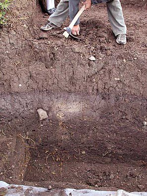
We succeeded in expanding our excavations on the land below the north side of the hill, more than doubling the size of our 2007 excavation and explored a feature which seems to be part of a cooking and food processing area. Below that were undisturbed cultural strata containing bones, ceramics, grinding stones, chipped stones and an abundance of charcoal. Carbonized seeds were recovered directly from the excavations and from the flotation samples. Preliminary identification indicates that both maize and beans were present, but as yet there has been no detailed, laboratory analysis of the remains. Charred residues recovered on sherds from cooking pots will be processed for phytolith and starch remains. With the abundant charcoal, there should be no problem dating these strata.
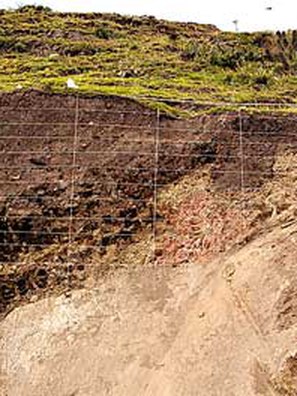
Time did not permit completion of these excavations to sterile, and it appears that the cultural deposits continue down at least another 50 cm, making the overall depth of deposit more than 2 m. We lined our excavation with plastic and backfilled the pits so that the excavations can be resumed at a later date. In addition to our excavations in this area, we cleaned a trench that had been excavated by the developer and drew the profile, which has clearly defined cultural strata.
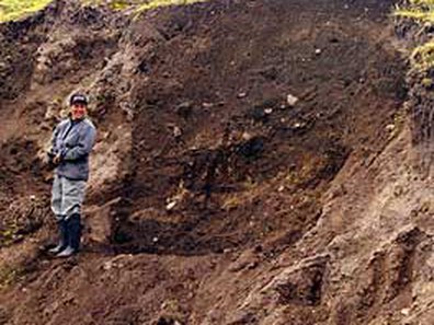
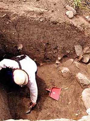
Cañaris residing along the south side of the hill identified a configuration of large stones on the site surface and in a cut face exposed by a modern irrigation canal as a tomb. Since no tomb has yet been excavated at Cerro Narrío by an archaeologist, though reputedly looters have dug up many tombs, we decided that we should excavate it before someone beat us to it. Our 2x2 m excavation did not reveal a tomb, but rather a number of boulders that had apparently tumbled down the hillside.
Using a 20x20 m grid we carried out a systematic surface collection, using a "dog-leash" strategy in which everything within a 2m radius around each node of the grid was collected. This resulted in a massive amount of artifacts that we hope to analyze next year. Since the site has been so thoroughly looted, a lot of material has been left on the surface. Our reasoning is that the surface collection may reveal differences in the kinds of activities that were carried out in various parts of the site and whether early occupations (as indicated by ceramic styles) were limited to certain sections. Also, our impressions from our casual observations are that there is surprisingly little shell or obsidian on the surface for a site that has been suggested to have been a major center for the exchange of such goods. Our systematic surface collection will allow us to evaluate that observation.
Conclusion
During the field season this year we spent time involving the Cañari community in the project. We already had strong ties with the leaders of the Cañari Union (UPCCC) from the project in 2007. They continued to strongly support our project. At the same time we traveled around to the paroquias, meeting with the local leaders and communities, explaining the importance of Cerro Narrío, and enlisting their help in defending the site. We were also able to employ some of the leadership to work with us on the site, and they became quite assertive in explaining what we were doing to any visitors at the site. By the end of the season, the Cañaris were discussing amongst themselves how they could act to conserve the site and were planning a minga (cooperative work project) to construct an interpretive centre. The director, assistant director and two archaeologists from the INPC in Cuenca also visited the site and were persuaded that the boundaries of the site are more extensive than they had believed. They also committed themselves to preventing further development on the site. The INPC may possibly buy all or part of the land owned by the developers. Whether that will come to pass, remains to be seen.
Although there is more that we had hoped to accomplish this past summer, all in all it was a very successful season. Our highest priority was in accurately defining the boundaries of Cerro Narrío and persuading the local people and the authorities that the site needs to be protected. We think we did as much as we could do toward that end-however, it will no doubt require periodic reinforcement.
Acknowlegements
Our research this summer was made possible by a project grant from Dumbarton Oaks, for which we am very grateful. Our 2007 work was supported by a University of Calgary Faculty Research Grant. Ms. Sonia Zarrillo also helped plan and direct the investigations. The able voluntary assistance of Mr. Danilo Delgado, and of some of his friends, was invaluable in meeting our goals. The Cañari community as a whole was very supportive of our work, but we wish to particularly acknowledge the assistance of Cesáreo Guamán G., president of the Instituto Ingapirka del Pueblo Kañar, and Antonio Caizan M, president of the UPCCC. The Subdireción Austro of the INPC was both co-operative and supportive. Dr. Joaquin Moscoso, subdirector, and Gerardo Castro, archaeologist, went out of their way to ensure the success of our project. The INPC also allowed us to reside in house built for archaeologists adjacent to the site of Ingapirca. Dr. Diego Quiroga of the Universidad de San Francisco was instrumental in securing storage and laboratory space.
References Cited
- Braun, Robert
1982 The Formative as Seen from the Southern Ecuadorian Highlands, in Primer Simposio de Correlaciones Antropológicas Andino-Mesoamericano, edited by Jorge G. Marcos and Presley Norton, pp. 41–119. Escuela Superior Politécnica del Litoral, Guayaquil. - Bruhns, Karen O.
1989 Intercambio entre la Costa y la Sierra en el Formativo Tardío: Nuevas Evidencias del Azuay. In Relaciones Interculturales en el Area Ecuatorial del Pacífico Durante la Epoca Precolombina, edited by J.F. Bouchard and M Guinea, pp. 57–74.British Archaeological Reports, International Series 503, Oxford. - 2003 Social and Cultural Development in the Ecuadorian Highlands and Eastern Lowlands during the Formative. In Archaeology of Formative Ecuador, edited by J.S. Raymond and Richard L. Burger, pp. 125–174. Dumbarton Oaks Research Library and Collection, Washington, D.C.
- Bruhns, Karen O. , James H, Burton, and George R. Miller
1990 Excavations at Pirincay in the Paute Valley of Southern Ecuador, 1985–1988. Antiquity 64:221–233. - Collier, Donald, and John V. Murra
1943 Survey and Excavations in Southern Ecuador. Field Museum of Natural History Anthropological Series 35, Publication 528, Chicago. - Lathrap, Donald W., Donald Collier, and Helen Chandra
1975 Ancient Ecuador: Culture, Clay, and Creativity. Field Museum, Chicago. - Uhle, Max
1922 Influencias Mayas en el Alto Ecuador. Boletín de la Academia Nacional de Historia 4:205–240.