Introduction
")
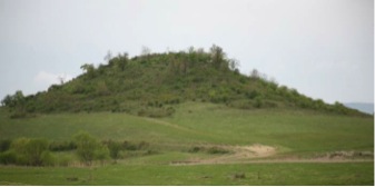
Immediately southwest of the village of Dobri Dyal, a small hill dominates the skyline. It is relatively small—ca. 110 m (west-east) by ca. 130 m (north-south), and only ca. 20 m high—but its western, northern, and eastern sides are precipitous, creating a strongly defensive position. The southern slope is more easily ascended, but even here it is still a steep climb to the summit.
")
The site was first visited by Gail Falkingham, Michael Boyd, and myself in the spring of 2007 and appeared to be the best “type site” in the region and, conveniently, a relatively short journey from the home base in the village of Nikiup.I am very grateful to Mr. Ivan Tsurov and Dr. Pavlinka Vladkova from the Veliko Turnovo Historical Museum whose intimate knowledge of all the sites in Veliko Turnovo county made the choice of the ones to visit such a successful field excursion. Conspicuous during this visit was a portion of wall without facing but comprising a section of mortared rubble core, ca. 1 m high, indicating that at least part of the curtain wall had survived postmedieval robbing.
")
Of all the sites visited during this exploratory survey of hilltop sites, Dobri Dyal was the one that both offered the most potential in the region and was accessible from the base in the village of Nikiup. The clearance of trees and undergrowth from the top of the hill, before the start of the excavations, exposed numerous robber pits. Although it is clear that robbing for stone had been carried out in the recent past, the depressions visible on the surface formed no distinctive pattern so that there would seem to have been no surface signs of buildings; the robbing appears to have been random and consequently it was expected that substantial portions of structures would have survived, particularly immediately inside the fortifications. There is only one record of earlier excavations; they were carried out by the local schoolteacher during the summer of 1933.Arheolocheski vesti, Izvestiya na Bulgarskiya Arheologicheski Institout, vol. 7 (1932–33), 393–95. The short report on the work included photographs which showed that a section of curtain wall had been exposed. Another find, described as a “tower,” may well have been the rounded northeastern corner of the defenses that we excavated this year (B3).
Excavations by our Bulgarian colleague, Dr. V. Dinchev, were carried out in areas D, F, G, and H, whereas the British half of the team commenced excavations in areas A, B, C, and E (plan of excavation areas). In addition, a detailed contour plan was made of the hill and its immediate surroundings (Gísli Pálsson), and a geophysical survey was conducted by Dr. Michael Boyd. The results of both projects were excellent and the combination of the physical and geophysical surveys proved invaluable for our understanding of the site and in the planning of future excavations.
")
The geophysical survey identified a strong high anomaly running around the northern, western, and eastern sides of the site. That this high resistance feature represented the course of the curtain wall was proved by the discovery that all the excavated portions of the wall (areas B, D, E, F, and G) followed the same alignment. However, more subtle differences between anomalies inside the fortifications suggested a curious arrangement of structures. The relatively high anomalies across the eastern side of the site suggest that there was a dense spread of buildings filling up the entire area. However, on the western slope, there was no sign of any buildings, except close up against the curtain wall (below, report by Michael Boyd). Another large building was also excavated by Dr. Dinchev in area D where it must have butted up against the curtain wall. It is early in the progress of the excavations to be sure that this difference between the western and eastern sides of the fortified area is correct but, assuming that it is, a number of possible explanations will be proposed in the conclusion.
As far as I am aware, no systematic excavations—or geophysical survey—have been carried out at the foot of any hilltop sites in the Balkans. Clearly, there was a possibility that the hilltop was only part of the settlement and that there may have been additional structures on the lower slopes surrounding the site and beyond the protection of the defenses. Accordingly, a geophysical survey was carried out over an extensive area on the south side of the hill. Not surprisingly, evidence for occupation was found; this evidence, though, was not for small individual houses but possibly very large structures or, more probably, enclosures.
The possible interpretation of this complex is provided by Dr. Boyd in his report but, suffice it to say that since no excavation has yet taken place here, it remains uncertain whether these features are late Roman or not. They may be late Roman, medieval, or postmedieval, or a combination of all three.
The Excavations
")
Area A
")
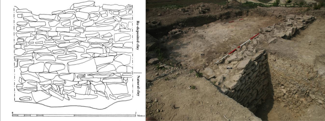
An area 7 m by 12 m was opened up on the south side of the hilltop. Although the southern end was cut by three deep robber holes, the northern half of the area was largely undisturbed. Below the topsoil, a clay layer of redeposited clay (6010), containing occasional fragments of brick and tile, covered the full extent of the area and, surprisingly, produced no sign of building foundations. Only two, possibly three, post-holes were located and these formed no obvious plan. However, one elongated small pit (6013), ca.1.20 m in length, contained a complete red deer antler, pottery, the base of a pot and bricks (see report by Rachael Billson). In the southern part of the area, a massive stone wall, bonded with earth, (6023), 1.15 m wide, passed across the full width of the area (7 m), and continued beyond the western and eastern baulks. Where the inner, northern face was excavated at the eastern end, it stood to a height of 1.64 m (see here). The wall had been cut into the natural hard clay and tip layers of redeposited clay (6028/6029, 1.10 m deep) butted up against the inside of the northern face of the wall. Damaged by robbing pits, the southern side of the wall was poorly preserved. Beyond, to the south, the excavation exposed another flat clay surface. Evidently, the purpose of the wall was to revet the upslope side of this lower platform. Only the lowest course of an earth and stone wall (2.57 m long and 0.75 m wide) protruded from the southern section (6025), evidently belonging to a building which lay south of the area.
Area B
")
The primary excavation (B1) was positioned on the northern edge of the plateau, a rectangular area 19 m west-east and 5 m north-south, within which there was no sign of robber holes on the surface. It was extended with a trench (2.50 m wide), running north toward the presumed line of the northern curtain wall. Despite initial optimism, the eastern side of B1 had been affected by robbing, particularly by one pit, which was backfilled with large stones. B2 explored a north-south rubble wall close to the presumed line of the defenses. B3 opened up another small area where the exposed rubble core, visible before excavation, indicated that at least one section of the defenses had survived robbing.
")
In B1, beneath a thin layer of humic soil and rubble, the primary occupation surface of yellow, redeposited clay (6508/6523), included small amounts of brick and a coin (SF 168), a worn issue of the late fourth or fifth century. Damaged on its northern side by a pit, a section of rubble and earth wall (6507), 0.50 m wide, emerged from the southern baulk and a second wall, bonded with the first, continued north. Evidently, this represents part of a building, extending south of the area. The most notable structure was another portion of a massive earth and stone wall (6545), standing 0.70 m high and 0.95 m wide, passed through the excavation, and and was aligned ENE-WSW. There is no doubt that this represents another section of the revetting wall, also located in area A and by our Bulgarian colleague, Dr. Dinchev, in area D. The northern face had collapsed but the southern side was well preserved, although, unlike the section uncovered in area A, it was not vertical but beveled appreciably, leaning to the north (see picture here). That this was intentional seems unlikely; more probably, it represents subsidence and/or an earthquake which also explains the collapse of the northern face.
Notable finds included, from a charcoal rich layer (6588) above the clay surface, a piece of scale armor (SF 804) and an arrowhead and coin (SF 165, issued in 310/11) from the bottom fill of a pit (6547). Cutting the clay surface (1.5 m x 0.75 m), a probable Grubenhaus (6575), with vertical sides (0.30m deep), was truncated on its northern side, close to the northern section.No fireplace was found, which would have added strength to this interpretation. Compare with the certain Grubenhaus in area C.
Within B2, part of another earth-bonded stone wall, up to five courses of roughly coursed stones bonded with earth (6552), orientated north-south, survived, with dimensions 0.76 m in height and 0.61 m in width. The curtain wall must have been immediately to the north and this short section of wall must have been part of a building that butted up against the inner side of the defenses.Note, this was not planned.
")
")
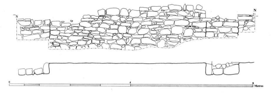
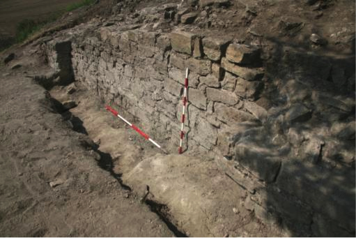
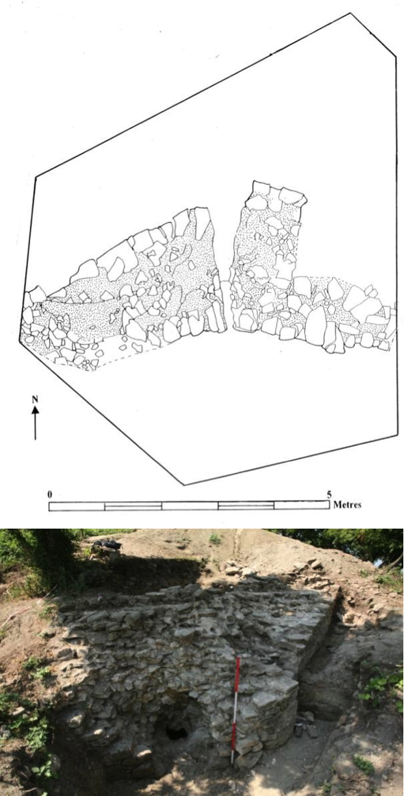
B3 produced a significant find: the northeastern corner of the outer defenses, exposed for a length of 6.80 m (see plan and photograph here). Although lacking tile courses, the inner and outer faces were made from irregular but well-dressed limestone blocks. The mortar was white to whitish-yellow in color and included pebbles and brick fragments. The wall varied between 2.15 and 2.50 m (at the corner) in width and its remains measured ca. 3 m high. There was no offset between the foundations and superstructure.
The outer face was substantially intact except where cut through by a crack in the wall, caused by subsidence. Nowhere was there any sign of walls projecting out from the curtain which could have belonged to a corner tower; no doubt the precipitous slope immediately beyond the defenses was a compelling reason not to build one, as the risk of subsidence could have resulted in the collapse of the curtain wall. However, bonded with the outer face of the curtain, there survived the foundations of a buttress (1.10 m wide and projecting 0.25 m from the wall), no doubt of similar form and function to those better surviving examples found in area E. On the outside of the wall, the foundation trench for the wall (6594) cut through a layer of burnt mudbrick (6596), possibly representing the collapse of burnt walls or more probably the use of burnt debris for leveling the site, immediately before the construction of the defenses. A similar spread of burnt mudbrick (6542) was uncovered on the inside of the wall which suggests that the floor surface inside the defenses has not been preserved because, above the mudbrick, the only level below topsoil comprised rubble and soil buildup, dating to the robbing of the site; no occupation surface or floor was found.
Area C
")
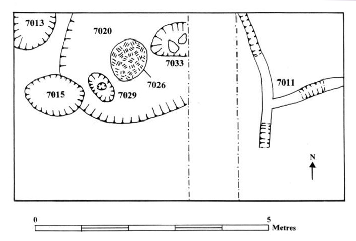
On the south-western crest of the hill, this area was 4 m north-south and 7 m west-east, subsequently extended to the west by a further 2 meters. A 2 m wide section was cut through the center of the area to determine whether the yellow clay (7007), immediately below topsoil, was redeposited or natural. The trench uncovered a lower layer of harder, chunky clay, identical in character to the natural clay found below redeposited clay in Area A. It follows that the lighter, silty clay (7007) above is naturally redeposited. In the eastern quarter of the excavation, there was no sign of structures, although two joining shallow cuts (7011) were sectioned and proved to be only 0.30 m deep and 0.10–0.25 m wide. Given their irregular course, they could not have been foundation trenches and were most probably drainage channels, cut to drain surface water away from the clay surface that covered the top of the hill. A possible rubbish pit (7013) was excavated in the northwestern corner of the area. A second pit, perhaps a robber hole (7015) cut the side of a Grubenhaus (7020). The building continued beyond the northern baulk and was cut by the sondage on its eastern side. Its vertical sides were 0.30m deep. In the center of a firm compacted clay floor was a fireplace (7026), 0.70 m in diameter, made of dark grey charcoal above a burnt clay surface. Immediately to the northeast there was a pit (7033), contemporary with the building; another (7029) on the other side of the fireplace proved to be a posthole (7029) with a central postpipe.
Area E
, area E (Poulter 2010–2011)")
")
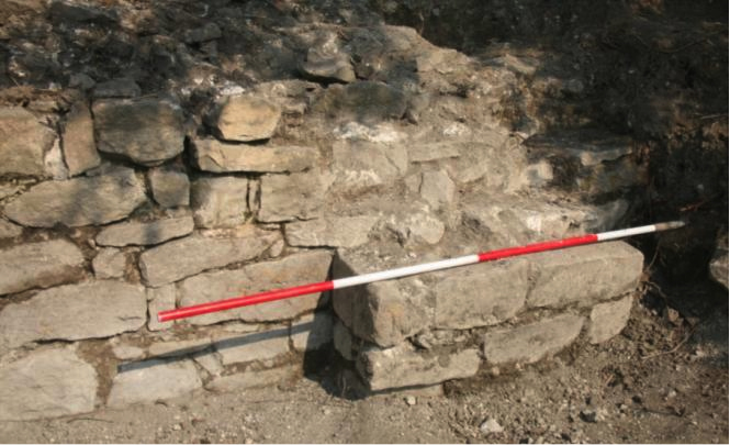
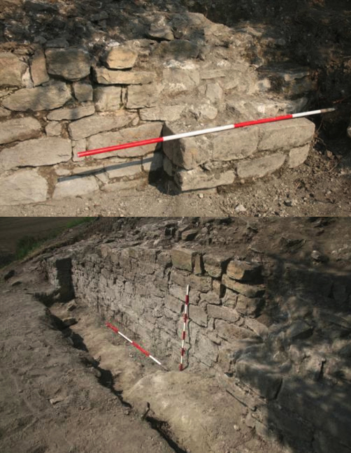
The most remarkable aspect of the curtain wall is the presence of two buttresses (see photographs here), here better preserved than the one identified at the northeastern corner of the curtain wall at Area B3. As in B3, both these buttresses were bonded with the curtain wall. They were 5.2 m apart. The northern buttress was 1.04 m wide and projected 0.53 m from the outer face of the wall. The southern buttress was 1.07 m in width and extended 0.38 m from the curtain where, immediately south of it, the wall changed orientation and headed southwest as it entered the baulk at the southern end of the area. These additional supports to the outer face of the defenses would have given additional support to the defensive wall which stood immediately above the steep, natural slope down the east side of the hill. Buttresses used in this way are not common. The sixth-century fortress of Sayganskoto Kale near Kipilovo had one curtain similarly equipped with external buttresses although at Dobri Dyal it seems likely that the entire circuit was reinforced with buttresses.See V. Dinchev, "The fortresses of Thrace and Dacia," in The Transition to Late Antiquity on the Danube and Beyond, ed. A. G. Poulter (Oxford and New York: Published for the British Academy by Oxford University Press, 2007), 525. Note, our Bulgarian colleagues have identified the foundations of another buttress reinforcing the western fortification wall (Area D) and further north on the eastern curtain (Area F). The only exception may have been the southern side where the slope, as described above, is appreciably less steep than elsewhere. Without excavation (in this disturbed area) this remains a possibility but remains unproven. With such a thick curtain wall, it is unlikely to have been less than ca. 8 m in height. The buttresses would have continued up to the crenulations to provide reinforcement and to strengthen the walls against subsidence and subsequent collapse.
Excavation then commenced to the west of the curtain, where we encountered, beneath topsoil, the collapsed remains of a wall (9007) entering the area at its southwestern corner. Toward the middle of the area a dark, ashy deposit (9006) extended the full width of the excavations, from the western baulk as far as the western face of the fortification wall. It seems possible that this is the remains of a burnt destruction level; it contained charred barley and patches of charcoal and was limited to the south by the cut of a west-east robber trench (9010). This trench may represent the line of a return wall that had originally bonded with the stub wall (4007) protruding from the southwestern corner of the area. What the relationship of this building was with the fortifications remains to be determined next year. Possibly, the ground level was higher behind the curtain wall than outside. If so, the wall might belong to the primary occupation level. However, it may also be that this is a late structure and that the level contemporary with the fortifications has not yet been reached. The latter explanation would seem the most probable since no clay surface (as in A and C) has yet been identified; the stone and earth wall may be sitting in the demolition level and was not contemporary with the curtain or belonged to the latest phase in the history of the fort.Against this is the clear difference between the lower, outer face of the wall superstructure in area B3 compared with the presumably higher occupation level inside the fortifications. See above, area B3
")
Mercifully, the photograph suggests that there had been no attempt to excavate to the west of the wall where intact deposits may exist although a trench, dug along the outer face of the wall, exposed the eastern face with its two buttresses. It follows that the deposits (9001/ 9003) removed this year to expose the face of the wall probably represent the lower backfills within the 1932 excavation trench.Arheolocheski vesti, Izvestiya na Bulgarskiya Arheologicheski Instituout, vol. 7 (1932–33): 395, fig. 148.
Conclusion
During the season of excavation, few uncontaminated in situ deposits were found. Consequently, conclusions about the site’s history and chronology remain provisional until further excavation has been carried out.
The archaeobotanical finds include a similar range of crops as was found at Dichin: Lens culinaris, Hordeum vulgare, Triticum sp., and possibly beans, Vicia faba (Dr. Pam Grinter).
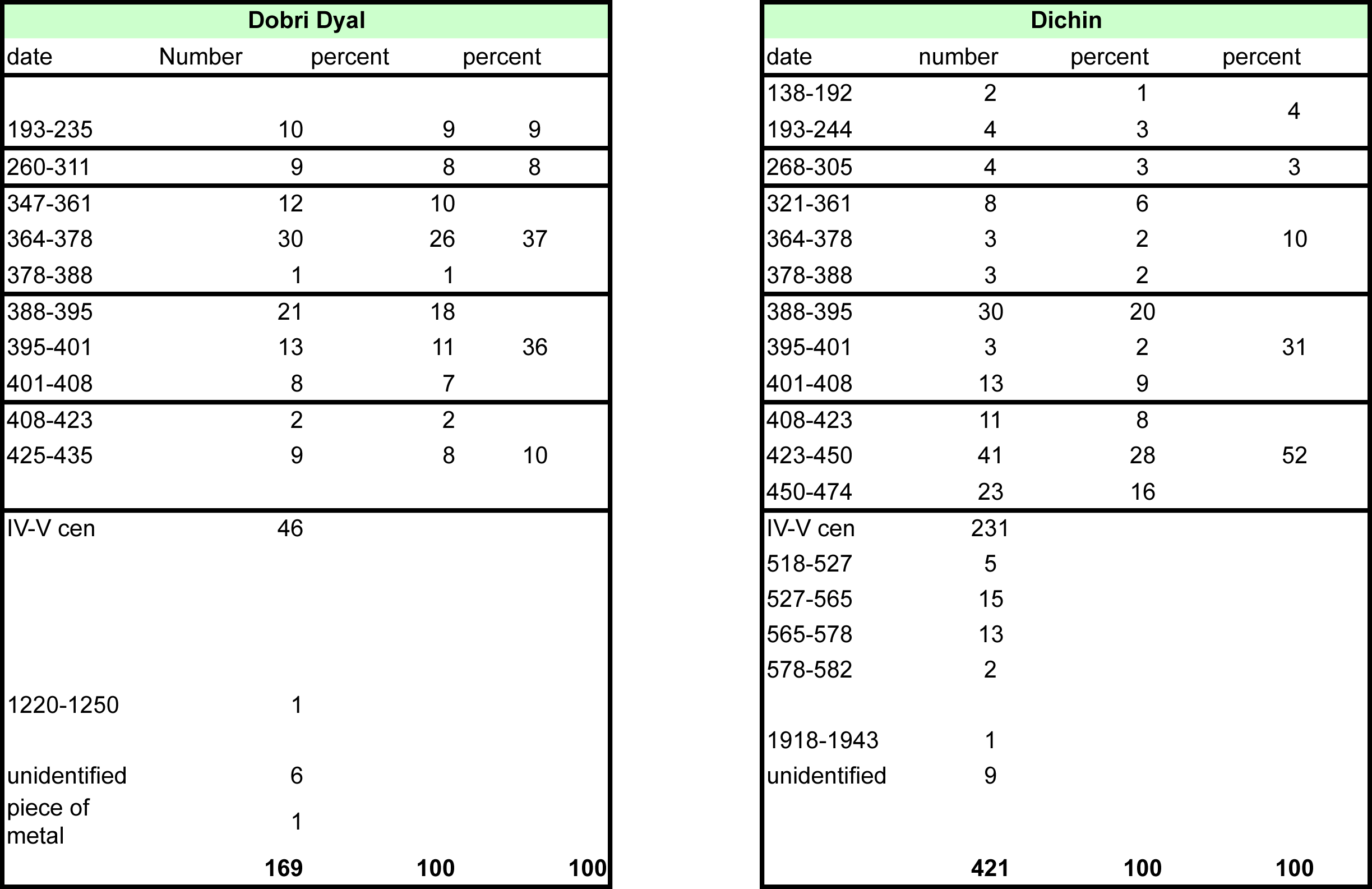
In addition, I am grateful to Mr. Stoyan Mihailov for identifying and providing full descriptions of the 169 coins recovered during this year’s excavations. This allows some tentative deductions to be made, although all but a couple come from unstratified contexts. The geophysical report by Dr. Boyd summarizes the impressive results of this season’s survey. A summary of the zooarchaeological results by Rachael Billson offers a valuable preliminary discussion on the animal bones.
It is highly probable that the site’s defensive potential was recognized in the prehistoric period. No stratified deposits of the pre-Roman period have yet been recognized although a closer study of the ceramic finds this summer should decide the issue. The first evidence for occupation, predating the construction of the fortress was noted in area B3 where the dump of burnt mudbrick, cut by the foundation trench for the curtain wall, indicates the existence of a building, its remains probably being used to level up outside and inside the defenses. No direct dating evidence is yet available for the mudbrick. However, as Dr. Mihailov points out in his coin report, coins dating from the second and third centuries are significantly more numerous at Dobri Dyal than at Dichin. That this indicates use of the site at this time is a reasonable presumption, but the nature of occupation remains uncertain. It could have been a military installation, a watchtower or fortlet built during the difficult years of the third century when the region was regularly invaded by barbarian tribes from across the Danube, a time when there is epigraphic evidence for fort building well south of the frontier. Alternatively, the hill-top may have had a temple; this could equally explain the presence of third-century coins. There is an increase in the number of coins in the period 364–378, which might be related to the construction of the fort, but there is reason for caution. The coin sequence is generally continuous from the third until the end of the fourth century and there is as yet no way of knowing if the coins should be associated with the use of the site before the fort was built or were lost after it was constructed. The number of coins increases again at the end of the fourth century and continues until it ceases with issues dating to 425–435, providing a terminus post quem of 425 for the abandonment of the site. This appears to contrast markedly with Dichin, which continued to be occupied until at least 473 and had issues datable later in the reign of Theodosius than was the case at Dobri Dyal, as well as of Marcian and Leo. It could be possible that the fort of Dobri Dyal was built either at some point in the second half of the fourth century or even early in the fifth century. A date of ca. 400 or later is given some support by the stratified coin from area B, found in the redeposited clay which can be no earlier than the very end of the fourth century or fifth century. But relying upon one single coin would be unwise; more dating evidence is needed.
It is possible that the fort was abandoned in the late 430s or, conveniently, during Attila’s invasion and devastation of Thrace in the 440s. Given the number of illegible fifth-century coins, this may not be true since they might include issues dating to the second half of the century. What is rather more significant is the total absence of the large sixth-century nummi found at Dichin and in other forts and towns in the region. The abandonment of forts in the interior ca. 450, which subsequently were never reoccupied in the sixth century, is true of sites such as the still-standing remains of a quadriburgium at Koula in western Bulgaria. It is curious that neither Koula—nor possibly Dobri Dyal—were reoccupied after the revival of Byzantine military control over the region under Anastasius (ca. 500), a control that continued down to the 580s. So far, this is speculative, partly because it is based on a comparatively small number of coins (169) and partly because of the lack of finds from well-stratified contexts. It is to be hoped that the excavations this coming year will provide a sounder basis for establishing a tighter chronology. Finally, the discovery of one later coin (1220–1250) is a reminder that it is possible that the site was reused in the medieval period. But, one coin is not conclusive evidence, any more than the single coin from area B provides a certain terminus post quem for the erection of the fortifications.
The strength of the fortifications and the quality of their construction rules out the possibility that this was a simple civilian refuge. Although lacking brick bonding courses (used at Dichin), the fortifications were well designed and well constructed; it must have had a military function, an interpretation strengthened somewhat by the discovery of scale armor in area B. One aspect of the construction process is worthy of note. There is no doubt that the leveling and building of the revetments represented a major operation, involving the redeposition of ca. 4,500 square meters of clay. This indicates, as much as the curtain wall, that this fort was founded as an important military stronghold. If it proves to be true that the fort survived for only a half century or so, this in itself would be valuable; it would provide evidence for the physical layout and economy of a Roman fort during the first half of the fifth century. The site of Dobri Dyal does not lie close to any known Roman road. However, there is little doubt that the modern road, heading east, offers a convenient route to the city of Marcianopolis and then to the Black Sea coast. It must have been used during the Roman period. To the south of Dobri Dyal, following the valley of the Zlatarska Reka, there was probably a branch road that was also used in Antiquity. This road led to a pass, immediately west of Choumana mountain, part of the Stara Planina (Haemus Mons), and then down into the Thracian Plain. The fortress would seem to have commanded a significant road junction of strategic importance.
Little can yet be determined about buildings within the site. The walls at the southern end of Area B1, in B2, and extending south from area A prove that buildings existed along the outer rim of the site, close to the defenses. The well-preserved earth and stone walls excavated by our colleague, Dr. Dinchev, in Areas D and G suggest that other structures await discovery. The fortifications, instead of surrounding the very crest of the hill are set lower down the slope, despite the consequent need for substantial engineering to create the circular route on the steep slope above the defenses. There was a perceived need to enclose as large an area as possible, even though this substantially increased the amount of work involved. Although the geophysical survey suggests that the eastern side of the hill must have been full of buildings, it is curious that, if space was at a premium, there appeared to be no structures on the western side of the hill. Why this was so remains a mystery. Area C contained a Grubenhaus, its fill producing burnt wattle-and-daub, a building material not associated with late Roman buildings (which have earth and stone walls, surmounted by mudbrick), but is common in the 6th century and the early medieval period. Grubenhäuser have not been found in Roman contexts. Its form is similar to those of the ninth and tenth centuries, such as the one excavated by the British team at Nicopolis. The roof would have been made from branches, placed wigwam fashion over the shallow cut. Inside, the most notable feature is a fireplace and a postpit, which must have contained a post but not one which supported the roof; given its structure, this would not have been necessary. The most obvious explanation is that this Grubenhaus is early medieval in date and postdates the abandonment of the fortress. The discovery of one thirteenth-century coin may be relevant here. However, the open space is not limited to area C but extends upslope, across the upper half of area A and the southern end of area B where a possible Grubenhaus has also been discovered. If there were more Grubenhäuser between B and C, that might account for the absence of high-resistance anomalies on the west side of the hill. If this proved to be true, then it implies that the buildings fell into two categories, those with stone and mudbrick of traditional late Roman type on the eastern slope and others, using Grubenhäuser on the west flank of the hill. So far none of the distinctive Slav pottery has been recognized from the site. If analysis proves that it is indeed absent then the occupation of these ‘medieval’ dwellings was either aceramic or else the occupants were using normal Roman pottery. Could this indicate a community of non-Roman origin sharing the site with a Roman garrison? At present, this is speculation but an idea worth keeping in mind when planning next season’s excavations. Such a situation would be surprising, especially if the site belongs only to the first half of the fifth century. The first influx of Slavs—who at least later on used Grubenhäuser—dates to the sixth and seventh centuries, when the site, on present evidence, had already been abandoned. The alternative explanation is that the Grubenhäuser represent the arrival of a new, non-Roman population—perhaps in the early medieval period—and that the newcomers simply reused the fort long after its abandonment by its early Byzantine garrison.
Whatever the exact date when the fort was abandoned (ca. 450?), there are slight indications from A, B, and E that it may have been associated with destruction by fire.
The first season at Dobri Dyal has proved exceptionally valuable, thanks in no small measure to the help and collaboration of our Bulgarian colleagues from the Institute of Archaeology, Sofia (Dr. Dinchev), and the staff of the Veliko Turnovo Museum (Dr. Pavlina Vladkova and Ivan Tsurov, in particular). I am most indebted to the British staff who volunteered to work with us for five weeks, and I would like to record my special thanks to all the students from Nottingham and Cardiff who worked so hard and responsibly in often difficult circumstances. It is to these that this short report is dedicated. I hope that the skills and experience have helped the archaeology students to understand more about the profession of archaeology, its weaknesses, its challenges and its potential.
Acknowledgments
I should like to express my thanks to the staff of Cardiff University for their generous assistance in allowing their students to participate in the program. Without the help of the staff of the Veliko Turnovo Historical Museum the Bulgaro-British team would not have been able to carry out such a successful season. I am also grateful to Dr. Ventsi Dinchev, my colleague, who did so much to assist in managing our joint programme.
I would like to acknowledge the generous support provided by Dumbarton Oaks, John Munnery, and the University of Nottingham (The Annual Fund) who financially supported this year’s excavations.
Specialist Report 1: The Coins
Stoyan Mihailov
The differences between the coins from the fort of Dichin and the new site of Dobri Dyal are particularly striking. Dobri Dyal has conspicuously more coins of the period 193–311 than Dichin. The new site also has a greater number of coins minted in the period 364–378. I suggest that this is the probable foundation date for the fortress. Accepting the dating of Theodosius II's "cross in wreath" issues to 425–435, it is noticeable that we have no coins that can be dated later than 435. Another eight minimi are of fifth-century date but are, unfortunately, worn and illegible.
")
Specialist Report 2: Dobri Dyal Bones, 2010 Report
Rachael Billson
")
Preservation of the Assemblage
")
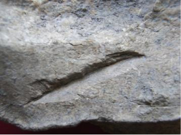
The bones from the site showed clear signs of root etching on over ten percent of the material recovered. Consequently it was difficult to identify evidence of taphonomic processes, such as butchery and animal gnawing, that occurred prior to deposition. The remains from the site were also fragmentary, with very few complete elements. As a result much of the material is identified by animal size class rather than by species.
Some of the deposits showed signs that they may have included material of different origins, possibly residual. This is seen in the fact that in some deposits most of the faunal material was a beige color, while a number of specimens showed signs of having been buried in an organically rich deposit and were dark brown in color. This is evidence of a mixed context.
Area A
Like much of the site, the bones recovered from this area were generally in poor condition and were highly fragmented. There were not sufficient numbers of bones from the majority of the contexts in this area to allow for a detailed analysis of their contents. However there were some contexts where the fragment count was high enough to allow for analysis.
One context (6013) is particularly noteworthy. This was a pit filled with a large quantity of what appeared to be Roman roofing tiles. In addition, the pit contained a variety of animal remains, including Sus Scufia, Ovis/Capra, and some unidentifiable fragments, as well as a red deer (Cervus elaphus) antler. This antler was broken above the brow tine just below the bez tine. The antler had a section of cranium attached and showed signs on the pedicle of attempts to remove it from the skull. These marks appear to have been made with a saw. Additionally, there are signs of charring at the base of the antler. The antler was in the center of the deposit, above which were the tiles and the base of a dish.
Area B
 (Poulter 2010–2011)")
This area contained the largest quantity of animal bone from the site. Time constraints mean that I have as of yet been unable to study the results in detail. There are almost 1,500 bones from this area. They appear to be in a fair condition (755 fragments) see attached tables for the data. Of the specimens from this context only 64 were not fragmentary. Additionally, 98 specimens show signs of root etching. The species recovered in this area are similar to the rest of the site, with the dominant species being Sus, followed by Ovis/Capra.
Area C
From this area only 61 specimens were recovered, of which 39 were unidentifiable. Only one specimen was not fragmented. Consequently, the material from this area is not able to provide much data for analysis.
Area D
This area produced in total of 241 fragments, the most common species being Sus with a total of 45 fragments. Of the specimens 30 were not fragmented, making this the area with the lowest level of fragmented material. Twenty-five of the fragments recovered had evidence of butchery. The level of preservation in this area was predominantly fair with 111 fragments and a further 59 fragments recorded as being well preserved. A find of note was the unfused femur of a horse.
Area E
The material from area E was highly fragmented; almost two-thirds of the 212 finds were fragments, 150 of which were not identifiable by species. There were 11 unfragmented specimens recovered from this area. Once again the most frequent species was Sus, followed by Ovis/Capra. The preservation is mostly fair, with an equal number of the bones in both the categories of good and poor.
Area F
In total there were 101 fragments recovered from this area, making it very difficult to draw any conclusions from these remains.
Area G
Only 2 bones were recovered from this area, both unidentifiable. This makes it impossible to say anything about the faunal remains.
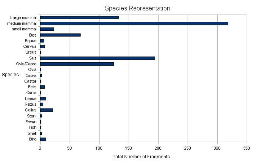
Species Representation
")
I had very little time with which to analyze the data from this site in detail by context and did not have phasing information; consequently, the species representation can only be looked at on a site-wide level as well as area by area. The most frequent species identified on the site was Sus, with 194 fragments identified in total. Of these fragments only one could confidently be identified as coming from a wild boar. This was a tusk, significantly larger than that of a domestic pig. The lack of time for bone recording meant that biometric measurements could not be taken and this means that the identification of other wild boar elements could not be identified during the season. The next most-frequently identified species was Ovis/Capra, 124 fragments of which were identified. Bones identified as belonging to other domesticates, such as Bos (68 fragments) and Equus (6 fragments) were relatively few in number.
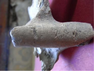
A number of wild species were represented in the assemblage, including beaver, deer (mainly red, 7 fragments in total), rabbits and hares (8 fragments in total), as well as a variety of wild birds such as storks and swans. In addition, a fragment of Ursus jaw was found in area B, context 6585 (see above, and other images). The fragment showed signs of disarticulation on the hinge.
Notes on the Assemblage
The material recovered included 867 bone fragments. Bones were identified by element, and of the finds only a quarter were identified as cranial fragments, and of these 125 did not have loose teeth. The relatively low number of cranial fragments indicates that much of the material was being supplied to the site as cuts of meat, rather than coming from animals slaughtered on site. This is supported by the lack of material representing the extremities of animals in the rest of the faunal material.
There are very few (27 in total) fragments of small vertebrates identified in the faunal assemblage. In addition, only 1 fragment of fish bone was found. Much of the animal bone was recovered from hand collection rather than sieving on site. Inevitably, this means that much of the material comes from larger animals.
Specialist Report 3: The Geophysics
Michael Boyd
Introduction and Method
Geophysical survey was carried out over 8 days during the Bulgarian/British excavations in July and August 2010 at the site of Dobri Dyal in north-central Bulgaria. The aim of the survey was twofold: to provide information on areas of the occupied hilltop not yet subject to excavation, and to investigate the lower slopes of the hill for any signs of occupation or other use beyond the fortification wall.
A total area of about 1.5 ha (15,488 square meters) was surveyed, divided between the hilltop area where 2,498 square meters were covered, and the south slope area, where 12,950 square meters were surveyed. The much smaller coverage on the hilltop is explained by the constrained area available for survey, that is, those sectors cleared of vegetation for survey but not yet under open excavation. The survey process was also considerably slower on the hilltop, due mainly to the difficult terrain, problematic both for the laying out of survey grids and for the operation of the survey. Nonetheless, it should be noted that almost all available space on the hilltop has now been surveyed. Survey proceeded at a greater rate on the south slopes, especially after the clearance of vegetation in those areas where otherwise survey could not have been possible.
The method used was exclusively electrical resistance survey, as in most previous campaigns in the region. The Geoscan RM15 instrument was used with readings taken at 1m intervals. Probe spacing was set at 0.5 m, ideal for features 0.5–0.75 m below the surface.
The Hilltop
")
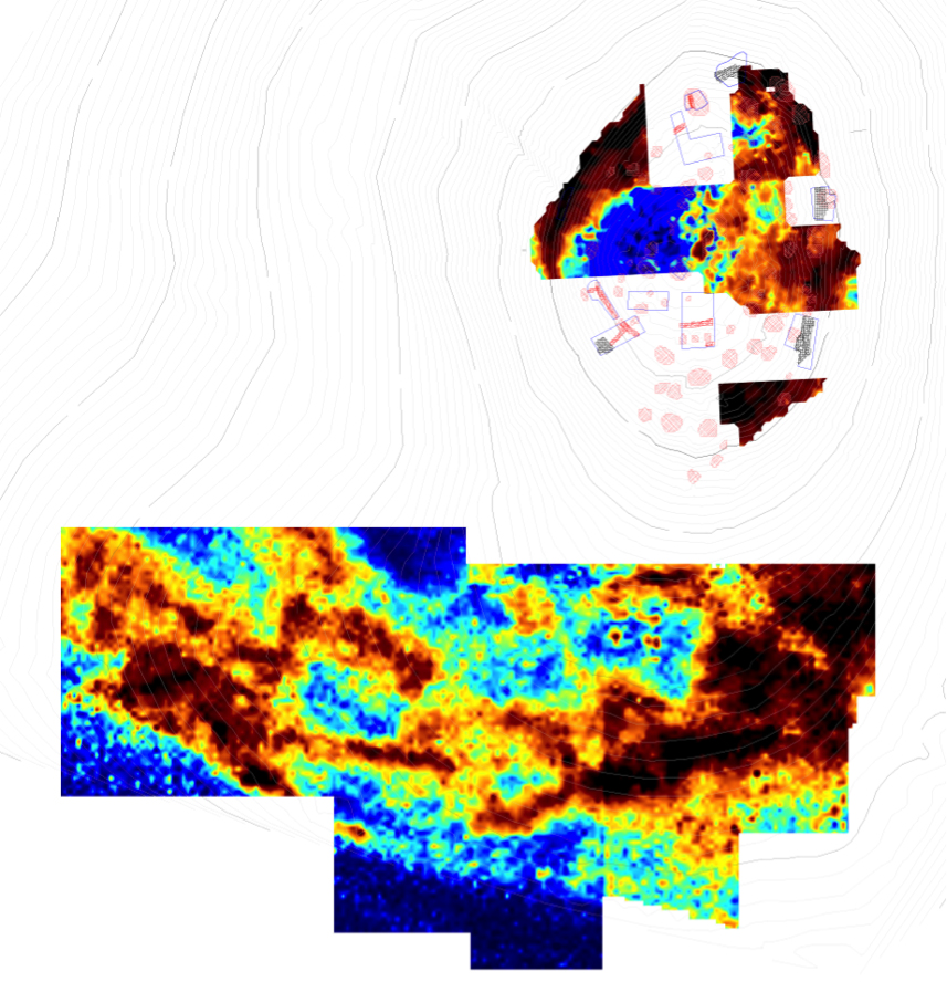
The longest stretch of the wall surveyed is in the northwest sector, where it has been detected over a distance of 48 m. Throughout, the wall is seen as an anomaly 4–6 m thick, though on the southern side it is markedly fainter and thinner, and it is at this point that it seems to turn through about 25 degrees to follow the contour round the hill. Kinks in the wall may well relate to built features, though the effects of collapse and robbing might be confusing the picture. At the northern end of this sector, an inward projection from the wall is about 12 m long and 7 m wide. This may be a feature built up against the wall. It should be noted that in places the outer face of the wall is beyond the edge of the survey area. The covering of vegetation on the lower slopes of the hill made survey there impossible, and outward facing features such as towers could not have been detected.
In the northeastern sector another section of the wall has been detected. This appears broken in two places: at the west, where it adjoins a section of excavated wall, the signal dips from 200Ω to 50Ω before rising again to 150Ω; then a few meters to the southeast, it dips from 125Ω to 50Ω before rising once again to 150Ω. These breaks might just be the effects of collapse and robbing, but because the wall here is at the very edge of the survey area, it is difficult to interpret whether they might be related to features to the north and west.
")
The final area surveyed is the small southeast quadrant. Here a core area about 6 x 6 m is 150Ω, while further west a wide area has readings of 50–90Ω, perhaps an area of collapse. Other features have been exposed in this area by unauthorized excavation. It might be possible for this area to be part of a gate complex, but further data are required to validate this hypothesis.
Aside from the very clear fortification wall, few other features have been clearly detected, all on the eastern slope. The western slope, including most of the summit area, shows no features at all, suggesting perhaps that such features are considerably deeper than 1 m. On the eastern slope and summit, while no features may be clearly detected, there seems to be a tendency for features to run north-east by south-west, and these may represent terracing or construction features.
The South Slopes
")
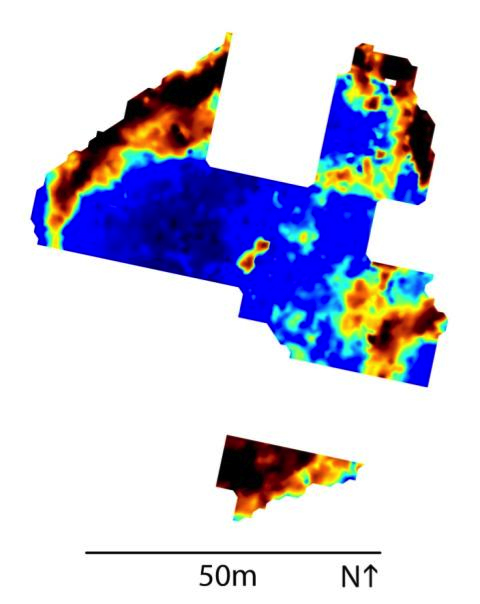
A wealth of features have been detected outside the fortification wall to the south, in an area extending at most 180 m east to west and 95 m north to south. These are broadly linear and oriented with the contour of the slope. The features are bizarre and no immediate explanation offers itself. They do not, for the most part, obviously constitute the remains of domestic architecture: most linear features are rather thick (3–4 m), and other elongated areas might be 7–8 m wide. Some of these features might represent the remains of enclosures, and others more likely represent collapsed buildings where no internal features can be discerned. Stronger features are up to 25Ω against a background of 11–13Ω; while this may seem very weak compared to the fortification wall just discussed, previous experience at other north-central Bulgarian sites suggests that architectural features can be extremely weak (~1Ω) and so features such as these at 12Ω above background are in fact rather strong. Weaker features in this area are still 5Ω or so above background.
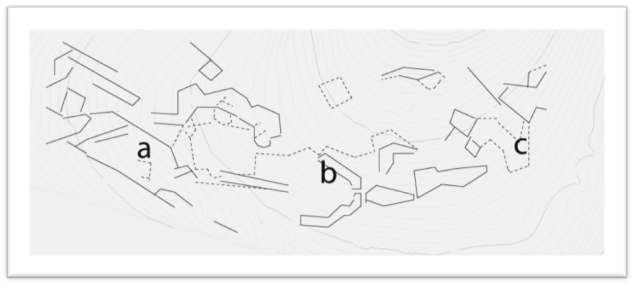
The north and northeast sections of the survey show a drop in background level of about 2Ω, which is quite clear in the images. This is due to the plowing of the field at this point. To the south, three major features may be picked out. Feature a (in the simplified results) is 40 x 17 m, with some indications of internal subdivision. Feature b is a horseshoe-shaped feature, which might conceivably be part of some sort of enclosure. Features further west (c) are hard to interpret but include areas of high resistance and some right angles, and most likely represent the remains of buildings.
")
-
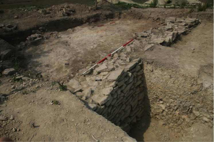
 Fig. 1: Dobri Dyal from the north, 2007 (Poulter 2010–2011)
Fig. 1: Dobri Dyal from the north, 2007.
Fig. 1: Dobri Dyal from the north, 2007 (Poulter 2010–2011)
Fig. 1: Dobri Dyal from the north, 2007.
-
 Fig. 2: Exposed core of the curtain wall, 2007 (Poulter 2010–2011)
Fig. 2: Exposed core of the curtain wall, 2007.
Fig. 2: Exposed core of the curtain wall, 2007 (Poulter 2010–2011)
Fig. 2: Exposed core of the curtain wall, 2007.
-
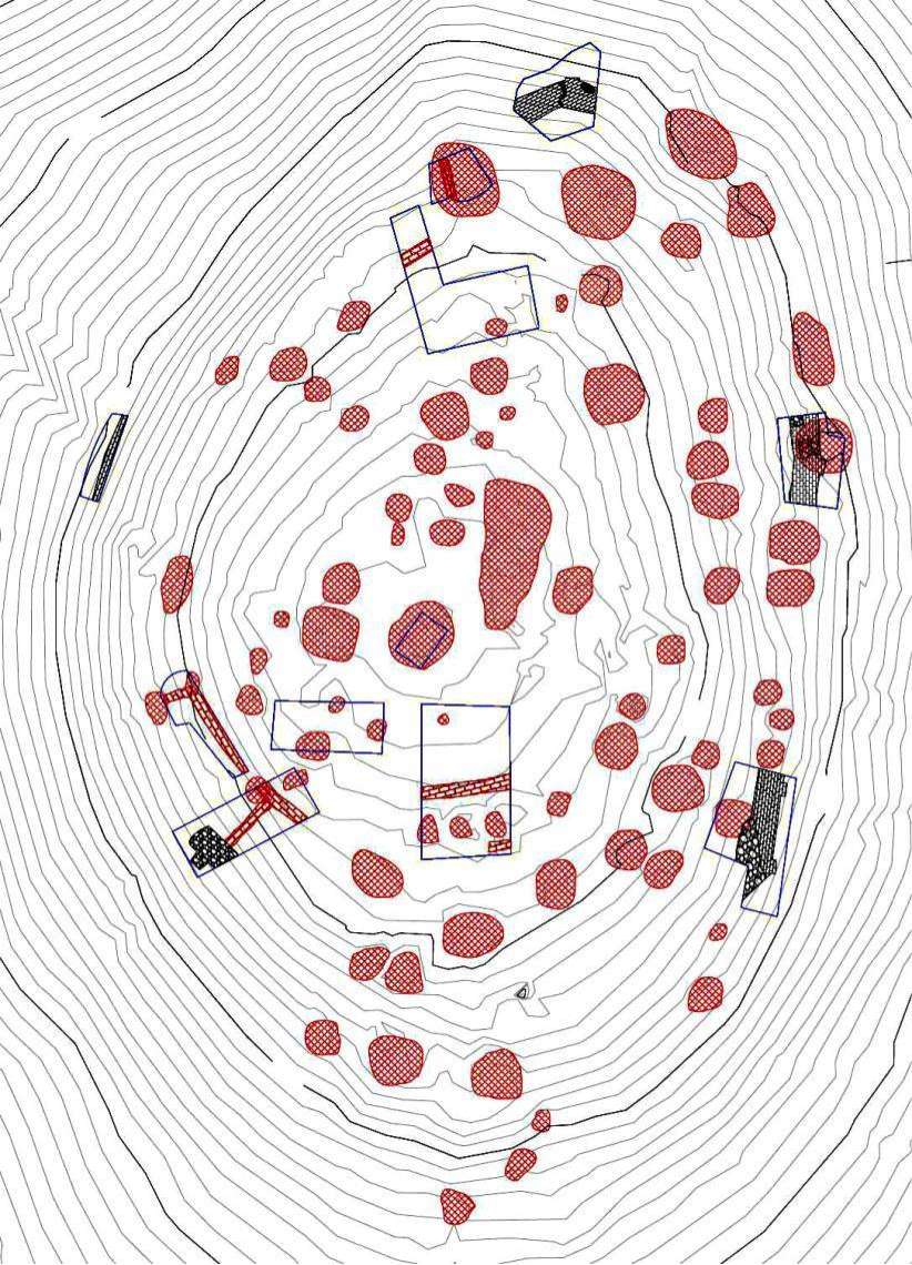
 Fig. 3: Contour plan of the sites with excavation areas and robber-pits, visible as surface features (Poulter 2010–2011)
Fig. 3: Contour plan of the sites with excavation areas and robber-pits, visible as surface features.
Fig. 3: Contour plan of the sites with excavation areas and robber-pits, visible as surface features (Poulter 2010–2011)
Fig. 3: Contour plan of the sites with excavation areas and robber-pits, visible as surface features.
-
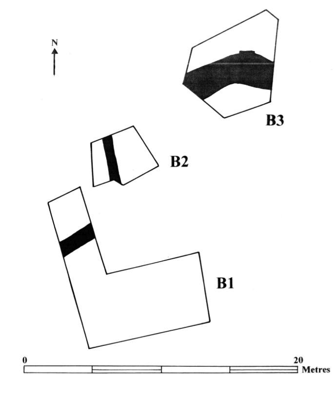
 Fig. 4: Excavation areas, 2010 (Poulter 2010–2011)
Fig. 4: Excavation areas, 2010.
Fig. 4: Excavation areas, 2010 (Poulter 2010–2011)
Fig. 4: Excavation areas, 2010.
-
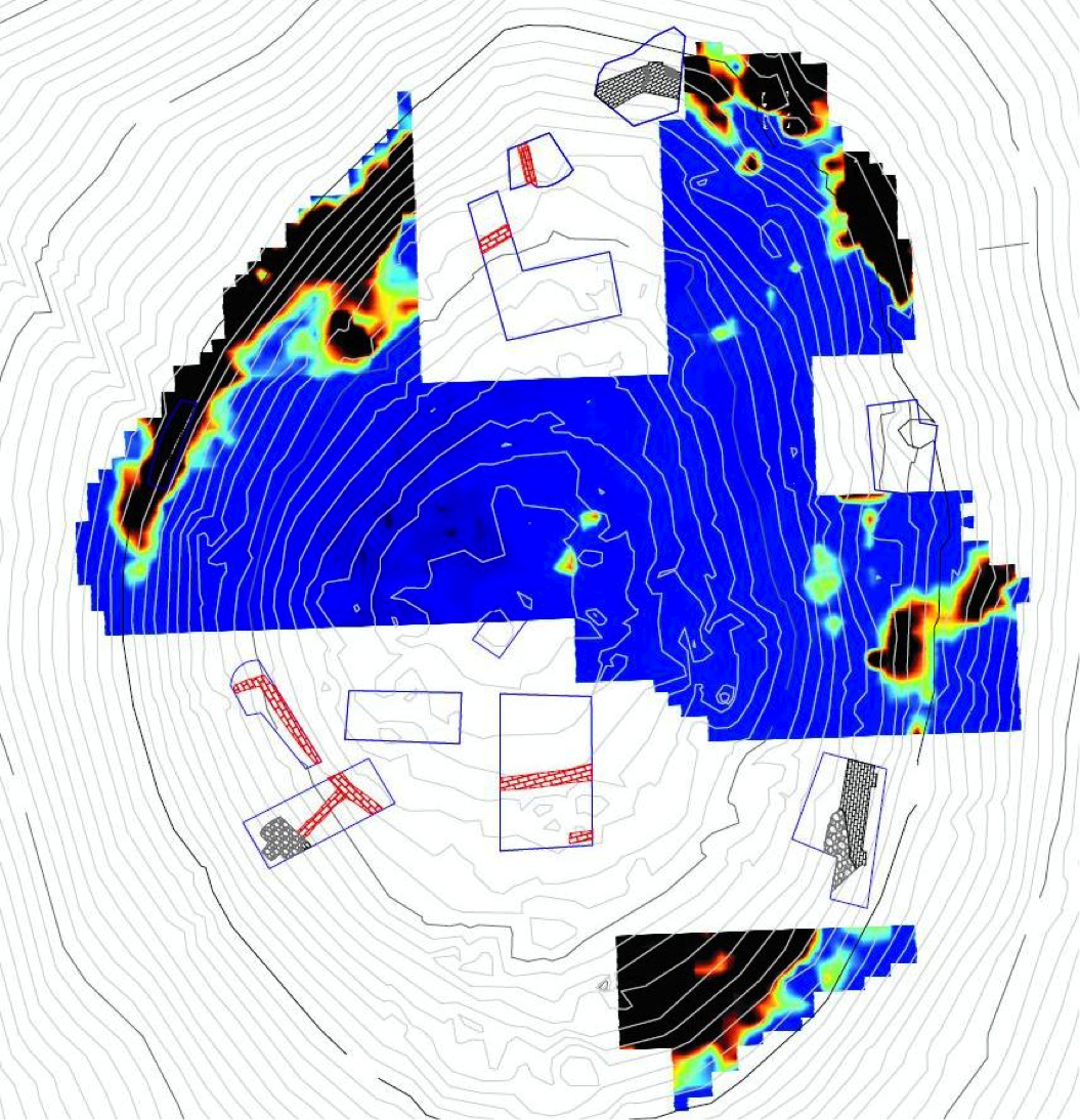
 Fig. 5: Site plan with excavation areas overlain by the geophysical survey (Poulter 2010–2011)
Fig. 5: Site plan with excavation areas overlain by the geophysical survey, showing the high anomaly, which represents the line of the curtain-wall.
Fig. 5: Site plan with excavation areas overlain by the geophysical survey (Poulter 2010–2011)
Fig. 5: Site plan with excavation areas overlain by the geophysical survey, showing the high anomaly, which represents the line of the curtain-wall.
-
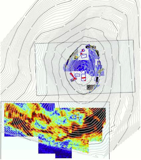
 Fig. 6: The hill (Poulter 2010–2011)
Fig. 6: The hill. Note the location of the high anomalies on the lower south side of the site.
Fig. 6: The hill (Poulter 2010–2011)
Fig. 6: The hill. Note the location of the high anomalies on the lower south side of the site.
-
 Fig. 7: The revetting wall (5023), area A (Poulter 2010–2011)
Fig. 7: The revetting wall (5023), area A.
Fig. 7: The revetting wall (5023), area A (Poulter 2010–2011)
Fig. 7: The revetting wall (5023), area A.
-
 Fig. 8: Northern face of the revetting wall, area A (Poulter 2010–2011)
Fig. 8: Northern face of the revetting wall, area A.
Fig. 8: Northern face of the revetting wall, area A (Poulter 2010–2011)
Fig. 8: Northern face of the revetting wall, area A.
-
 Fig. 9: Area A (Poulter 2010–2011)
Fig. 9: Area A.
Fig. 9: Area A (Poulter 2010–2011)
Fig. 9: Area A.
-
 Fig. 10: Area B (Poulter 2010–2011)
Fig. 10: Area B.
Fig. 10: Area B (Poulter 2010–2011)
Fig. 10: Area B.
-
 Fig. 11: Area B1 (Poulter 2010–2011)
Fig. 11: Area B1.
Fig. 11: Area B1 (Poulter 2010–2011)
Fig. 11: Area B1.
-
 Fig. 12: The revetting wall (6545), area B (Poulter 2010–2011)
Fig. 12: The revetting wall (6545), area B.
Fig. 12: The revetting wall (6545), area B (Poulter 2010–2011)
Fig. 12: The revetting wall (6545), area B.
-
 Fig. 13: The northeastern corner of the defenses, area B3 (Poulter 2010–2011)
Fig. 13: The northeastern corner of the defenses, area B3. Note the projecting buttress.
Fig. 13: The northeastern corner of the defenses, area B3 (Poulter 2010–2011)
Fig. 13: The northeastern corner of the defenses, area B3. Note the projecting buttress.
-
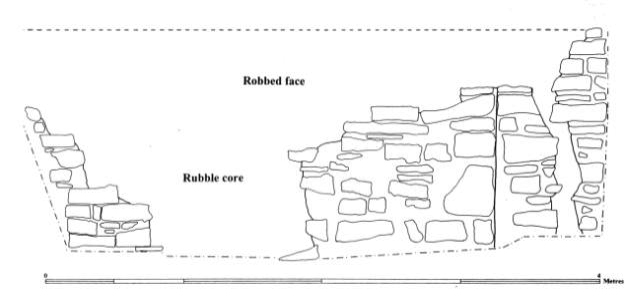
 Fig. 14: Plan of the northeastern corner with external buttress, area B3 (Poulter 2010–2011)
Fig. 14: Plan of the northeastern corner with external buttress, area B3.
Fig. 14: Plan of the northeastern corner with external buttress, area B3 (Poulter 2010–2011)
Fig. 14: Plan of the northeastern corner with external buttress, area B3.
-
 Fig. 15: External elevation of the northeastern corner (Poulter 2010–2011)
Fig. 15: External elevation of the northeastern corner. Note preserved right side of the offset and, far right, a crack in the curtain, probably due to subsidence, area B3.
Fig. 15: External elevation of the northeastern corner (Poulter 2010–2011)
Fig. 15: External elevation of the northeastern corner. Note preserved right side of the offset and, far right, a crack in the curtain, probably due to subsidence, area B3.
-
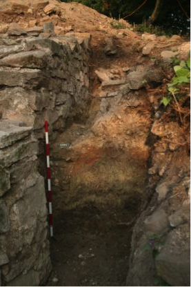
 Fig. 16: Foundation cut for external face of the curtain wall, area B3 (Poulter 2010–2011)
Fig. 16: Foundation cut for external face of the curtain wall, area B3.
Fig. 16: Foundation cut for external face of the curtain wall, area B3 (Poulter 2010–2011)
Fig. 16: Foundation cut for external face of the curtain wall, area B3.
-
 Fig. 17: Foundation cut for the external face of the curtain wall, area B3 (Poulter 2010–2011)
Fig. 17: Foundation cut for the external face of the curtain wall, area B3.
Fig. 17: Foundation cut for the external face of the curtain wall, area B3 (Poulter 2010–2011)
Fig. 17: Foundation cut for the external face of the curtain wall, area B3.
-
 Fig. 18: Plan of area C (Poulter 2010–2011)
Fig. 18: Plan of area C.
Fig. 18: Plan of area C (Poulter 2010–2011)
Fig. 18: Plan of area C.
-
 Fig. 19: The outer face of the curtain wall, area E (Poulter 2010–2011)
Fig. 19: The outer face of the curtain wall, area E.
Fig. 19: The outer face of the curtain wall, area E (Poulter 2010–2011)
Fig. 19: The outer face of the curtain wall, area E.
-
 Fig. 20: Outer eastern face of the curtain wall (9005), area E (Poulter 2010–2011)
Fig. 20: Outer eastern face of the curtain wall (9005), area E.
Fig. 20: Outer eastern face of the curtain wall (9005), area E (Poulter 2010–2011)
Fig. 20: Outer eastern face of the curtain wall (9005), area E.
-
 Fig. 21: Outer face of curtain-wall and northern buttress, area E (Poulter 2010–2011)
Fig. 21: Outer face of curtain-wall and northern buttress, area E.
Fig. 21: Outer face of curtain-wall and northern buttress, area E (Poulter 2010–2011)
Fig. 21: Outer face of curtain-wall and northern buttress, area E.
-
 Fig. 22: Outer face of curtain wall and southern buttress, area E (Poulter 2010–2011)
Fig. 22: Outer face of curtain wall and (above left), southern buttress, area E.
Fig. 22: Outer face of curtain wall and southern buttress, area E (Poulter 2010–2011)
Fig. 22: Outer face of curtain wall and (above left), southern buttress, area E.
-
 Fig. 23: Photograph taken of a section of the upstanding defenses, excavated in 1933 (Poulter 2010–2011)
Fig. 23: Photograph taken of a section of the upstanding defenses, excavated in 1933.
Fig. 23: Photograph taken of a section of the upstanding defenses, excavated in 1933 (Poulter 2010–2011)
Fig. 23: Photograph taken of a section of the upstanding defenses, excavated in 1933.
-
 Fig. 24: Comparison of coin finds from Dobri Dyal and Dichin (Poulter 2010–2011)
Fig. 24: Comparison of coin finds from Dobri Dyal and Dichin (Mihailov).
Fig. 24: Comparison of coin finds from Dobri Dyal and Dichin (Poulter 2010–2011)
Fig. 24: Comparison of coin finds from Dobri Dyal and Dichin (Mihailov).
-
 Fig. 25: Signs of root etching on a specimen from Dobri Dyal (Poulter 2010–2011)
Fig. 25: Signs of root etching on a specimen from Dobri Dyal (Billson)
Fig. 25: Signs of root etching on a specimen from Dobri Dyal (Poulter 2010–2011)
Fig. 25: Signs of root etching on a specimen from Dobri Dyal (Billson)
-
 Fig. 26a: Mandible of Ursus of recovered from context 6585 (area B) (Poulter 2010–2011)
Fig. 26a: Mandible of Ursus of recovered from context 6585 (area B) (Billson).
Fig. 26a: Mandible of Ursus of recovered from context 6585 (area B) (Poulter 2010–2011)
Fig. 26a: Mandible of Ursus of recovered from context 6585 (area B) (Billson).
-
 Fig. 26b: Detail of cuts on the madibular hinge of Ursus mandible recovered from context 6585 (area B) (Poulter 2010–2011)
Fig. 26b: Detail of cuts on the madibular hinge of Ursus mandible recovered from context 6585 (area B) (Billson).
Fig. 26b: Detail of cuts on the madibular hinge of Ursus mandible recovered from context 6585 (area B) (Poulter 2010–2011)
Fig. 26b: Detail of cuts on the madibular hinge of Ursus mandible recovered from context 6585 (area B) (Billson).
-
 Fig. 26c: Detail of cut on the bucal aspect of Ursus mandible recovered from context 6585 (area B) (Poulter 2010–2011)
Fig. 26c: Detail of cut on the bucal aspect of Ursus mandible recovered from context 6585 (area B) (Billson).
Fig. 26c: Detail of cut on the bucal aspect of Ursus mandible recovered from context 6585 (area B) (Poulter 2010–2011)
Fig. 26c: Detail of cut on the bucal aspect of Ursus mandible recovered from context 6585 (area B) (Billson).
-
 Fig. 27: Wild boar tusk in comparison to that of a domestic pig (Poulter 2010–2011)
Fig. 27: Wild boar tusk in comparison to that of a domestic pig (Billson).
Fig. 27: Wild boar tusk in comparison to that of a domestic pig (Poulter 2010–2011)
Fig. 27: Wild boar tusk in comparison to that of a domestic pig (Billson).
-
 Fig 28: Graph showing the basic species representation for the site as a whole based on the total number of fragments for each species (Poulter 2010–2011)
Fig 28: Graph showing the basic species representation for the site as a whole based on the total number of fragments for each species (Billson).
Fig 28: Graph showing the basic species representation for the site as a whole based on the total number of fragments for each species (Poulter 2010–2011)
Fig 28: Graph showing the basic species representation for the site as a whole based on the total number of fragments for each species (Billson).
-
 Fig. 29: The defenses (Poulter 2010–2011)
Fig. 29: The defenses (Boyd).
Fig. 29: The defenses (Poulter 2010–2011)
Fig. 29: The defenses (Boyd).
-
 Fig. 30: The hilltop with the high resistance features only on the east slope (Poulter 2010–2011)
Fig. 30: The hilltop with the high resistance features only on the east slope (Boyd).
Fig. 30: The hilltop with the high resistance features only on the east slope (Poulter 2010–2011)
Fig. 30: The hilltop with the high resistance features only on the east slope (Boyd).
-
 Fig. 31: The lower southern slope of the hill (Poulter 2010–2011)
Fig. 31: The lower southern slope of the hill (Boyd).
Fig. 31: The lower southern slope of the hill (Poulter 2010–2011)
Fig. 31: The lower southern slope of the hill (Boyd).
-
 Fig. 32: Interpretation of structures on the southern side of the hill (Poulter 2010–2011)
Fig. 32: Interpretation of structures on the southern side of the hill (Boyd).
Fig. 32: Interpretation of structures on the southern side of the hill (Poulter 2010–2011)
Fig. 32: Interpretation of structures on the southern side of the hill (Boyd).


